 Filter: Categories of Wisconsin Historical Images
Filter: Subject of Taverns (Inns)
Filter: Year of 1800-1899
Filter: Categories of Wisconsin Historical Images
Filter: Subject of Taverns (Inns)
Filter: Year of 1800-1899

| Date: | 1858 |
|---|---|
| Description: | An ink on paper map of Milwaukee County and the eastern portion of Waukesha County that shows the townships of Oak Creek, Franklin, Greenfield, Wauwatosa, ... |

| Date: | 1870 |
|---|---|
| Description: | This 1870 map of Brown County, Wisconsin, shows the township and range grid, towns, sections, cities, villages and post offices, land ownership, roads, rai... |
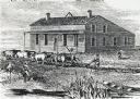
| Date: | 1840 |
|---|---|
| Description: | Sod-breaker and five yoke of oxen plowing in front of the “Old Cottage Inn.” In the foreground a boat is on the shoreline. |

| Date: | 1856 |
|---|---|
| Description: | This map is ink and watercolor on tracing paper and shows plat of city, local streets, block numbers, topography, several buildings, and includes an explan... |

| Date: | 1884 |
|---|---|
| Description: | Stereograph of an elevated view of a snowy street in a town. There is a sign for the Palace Saloon in the foreground on the left. Across the street is the ... |
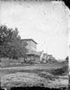
| Date: | 1890 |
|---|---|
| Description: | View across unpaved road towards a row of buildings on the other side. A fence and trees are on the left, and in front of the first building a group of men... |
If you didn't find the material you searched for, our Library Reference Staff can help.
Call our reference desk at 608-264-6535 or email us at: