 Filter: Categories of Wisconsin Historical Images
Filter: Subject of Taverns (Inns)
Filter: Subject of cities and towns
Filter: Subject of transportation
Filter: Categories of Wisconsin Historical Images
Filter: Subject of Taverns (Inns)
Filter: Subject of cities and towns
Filter: Subject of transportation

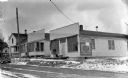
| Date: | |
|---|---|
| Description: | Group of men and boys posed standing in front of a wooden building, probably a tavern. The photographer's wagon is in the background. |
| Date: | 1937 |
|---|---|
| Description: | View across road of a man and a dog standing on the front stoop of a one-story building that has a sign that reads “Art’s Lunches and Confectionery, Ask fo... |
| Date: | 05 1972 |
|---|---|
| Description: | Spring scene on Wall Street. The building is the Arbutus Inn, hotel, bar and dining room. It was also the original Snowmobile Hall of Fame. Two boys are st... |

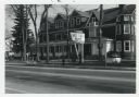
| Date: | 1975 |
|---|---|
| Description: | "Main (Milwaukee) Street. Six taverns were in business in the span of one block!" |
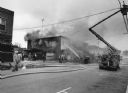
| Date: | 11 1991 |
|---|---|
| Description: | "With windchill factors below zero, firemen battled this fire at Das Pioneer Bier haus, operated by Mike Polster. Former proprietors were John Miller, Henr... |

| Date: | |
|---|---|
| Description: | View across unpaved street towards two men in a buggy drawn by a team of two horses in front of the Merchants Inn. |

| Date: | 1858 |
|---|---|
| Description: | An ink on paper map of Milwaukee County and the eastern portion of Waukesha County that shows the townships of Oak Creek, Franklin, Greenfield, Wauwatosa, ... |

| Date: | 1870 |
|---|---|
| Description: | This 1870 map of Brown County, Wisconsin, shows the township and range grid, towns, sections, cities, villages and post offices, land ownership, roads, rai... |

| Date: | 1941 |
|---|---|
| Description: | This 1941 map covers Washburn County, Wisconsin, as well as western Sawyer, eastern Burnett, and northeastern Polk counties. It shows the locations of tour... |

| Date: | 11 1991 |
|---|---|
| Description: | Landmark tavern in Theresa demolished to make way for highway improvement plan. |

| Date: | |
|---|---|
| Description: | View across unpaved street towards a group of people posing sitting on a stagecoach pulled by a team of four horses wearing flynets. The stagecoach is in f... |

| Date: | 1856 |
|---|---|
| Description: | This map is ink and watercolor on tracing paper and shows plat of city, local streets, block numbers, topography, several buildings, and includes an explan... |
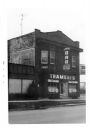
| Date: | 1974 |
|---|---|
| Description: | An exterior view of Trameri's Bar at 625 West Main Street. |

| Date: | 05 07 2012 |
|---|---|
| Description: | Dusk in downtown Beetown. View down curved street towards an illuminated Hamms sign on a building along the block on the left. A sign that reads "Beetown F... |

| Date: | 06 12 1929 |
|---|---|
| Description: | This manuscript blueprint shows buildings with the names of their owners, tabernacle, location "where Strang found plates" and "house where Strang died," a... |

| Date: | 1943 |
|---|---|
| Description: | This map shows roads, trails, taverns, schools, golf, gas stations, campsites, resorts, and towers. The lower left of the map includes a legend. The map co... |
| Date: | 1907 |
|---|---|
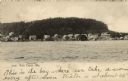
| Description: | View of Fish Creek from the bay, with the main dock in the center, and the White Gull Inn on the right. Caption reads: "Fish Creek, Wis." |

| Date: | |
|---|---|
| Description: | Black and white photographic postcard of the Hotel Blackhawk, a large brick building on a corner in the downtown area. Automobiles and buses are at the int... |
| Date: | |
|---|---|
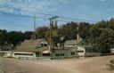
| Description: | Color postcard view from intersection towards a roadside tavern. Text on reverse reads: "TIBBIES Where Chicken is King at Indian Ford, Wis. Three miles... |

| Date: | 1884 |
|---|---|
| Description: | Stereograph of an elevated view of a snowy street in a town. There is a sign for the Palace Saloon in the foreground on the left. Across the street is the ... |
If you didn't find the material you searched for, our Library Reference Staff can help.
Call our reference desk at 608-264-6535 or email us at: