 Filter: Categories of Wisconsin Historical Images
Filter: Subject of Surveying
Filter: Year of 1900-1999
Filter: Year of 1900-1909
Filter: Categories of Wisconsin Historical Images
Filter: Subject of Surveying
Filter: Year of 1900-1999
Filter: Year of 1900-1909
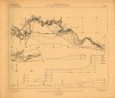
| Date: | 1906 |
|---|---|
| Description: | Portion of title: Eau Claire River, Wisconsin. Relief shown by contours and spot heights. Contour interval on land 5 feet. Contour interval on river surfac... |

| Date: | 1900 |
|---|---|
| Description: | A class of engineering students practicing surveying in front of Science Hall, located on the University of Wisconsin (Madison) campus. Eleven engineering ... |

| Date: | 1903 |
|---|---|
| Description: | This map shows lakes, rivers, railroads, and the soil types of towns and counties. A legend of soil types and conventional signs is included. Relief is sho... |
If you didn't find the material you searched for, our Library Reference Staff can help.
Call our reference desk at 608-264-6535 or email us at: