 Filter: Categories of Wisconsin Historical Images
Filter: Subject of Surveying
Filter: Year of 1800-1899
Filter: Year of 1880-1889
Filter: Categories of Wisconsin Historical Images
Filter: Subject of Surveying
Filter: Year of 1800-1899
Filter: Year of 1880-1889

| Date: | 06 1887 |
|---|---|
| Description: | A map of southern Wisconsin, from the Illinois state border in the south to Rocky Run, Wisconsin in the north for the Coast and Geodetic Survey, showing th... |

| Date: | 1882 |
|---|---|
| Description: | Plat map of the village of Dunbarton, received by the Lafayette County Register's Office on September 22, 1892. Certification by the surveyor, Albert Pool,... |
| Date: | 1882 |
|---|---|
| Description: | Note from Albert Pool, surveyor for the village of Dunbarton in Lafayette County, as appears on the reverse of the Village of Dunbarton plat map. Pool cert... |
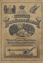
| Date: | 1886 |
|---|---|
| Description: | Front cover featuring illustrations of wheeled scrapers, drag scrapers, railroad plows and road graders. |

| Date: | 1880 |
|---|---|
| Description: | A map of Milwaukee which includes a city street guide. |
If you didn't find the material you searched for, our Library Reference Staff can help.
Call our reference desk at 608-264-6535 or email us at: