 Filter: Categories of Wisconsin Historical Images
Filter: Subject of Surveying
Filter: Subject of water
Filter: Year of 1900-1999
Filter: Categories of Wisconsin Historical Images
Filter: Subject of Surveying
Filter: Subject of water
Filter: Year of 1900-1999

| Date: | 1911 |
|---|---|
| Description: | Workers erecting a steam driven pile driver while others survey for the railroad extension from the village of Prairie du Sac to the dam site on the Wiscon... |

| Date: | 1923 |
|---|---|
| Description: | This topographical map of Devil's Lake State Park, Sauk County, Wisconsin, is based on 1922-1923 surveys of the area by the University of Wisconsin Summer ... |
| Date: | 1906 |
|---|---|
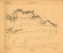
| Description: | Portion of title: Eau Claire River, Wisconsin. Relief shown by contours and spot heights. Contour interval on land 5 feet. Contour interval on river surfac... |
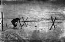
| Date: | 1918 |
|---|---|
| Description: | Outdoor view of a U.S. Army Engineer topographer wearing skis while in the process of surveying land. The engineer is standing next to a barbed wire obstac... |

| Date: | 1918 |
|---|---|
| Description: | Outdoor view of a U.S. Army Engineer topographer wearing skis while using a tripod stand to write. The engineer is standing next to a barbed wire obstacle ... |

| Date: | 1900 |
|---|---|
| Description: | A class of engineering students practicing surveying in front of Science Hall, located on the University of Wisconsin (Madison) campus. Eleven engineering ... |

| Date: | 1930 |
|---|---|
| Description: | Original map made with watercolor and inkwash. Includes a legend of buildings, roads, natural features and other details of the lodge. Inset at bottom has ... |

| Date: | 1903 |
|---|---|
| Description: | This map shows lakes, rivers, railroads, and the soil types of towns and counties. A legend of soil types and conventional signs is included. Relief is sho... |

| Date: | 1975 |
|---|---|
| Description: | This map provides an index of quadrangle maps for the state. The lower left corner contains explanation land surveying completeness. Communities, counties,... |

| Date: | 1975 |
|---|---|
| Description: | This map provides an index of outdated quadrangle maps for the state. Communities, counties, rivers, and lakes are labeled including Lake Michigan and Lake... |

| Date: | 04 11 1940 |
|---|---|
| Description: | This blue line print map shows survey monument markers by type and industrial buildings and covers part of the lower Fox River and East River. The map incl... |

| Date: | 1950 |
|---|---|
| Description: | This photocopy of a manuscript map shows sectional township grid, hydrography, and acreages as they appeared in 1836. The township lines surveyed by Mullet... |
If you didn't find the material you searched for, our Library Reference Staff can help.
Call our reference desk at 608-264-6535 or email us at: