 Filter: Categories of Wisconsin Historical Images
Filter: Subject of Surveying
Filter: Subject of land
Filter: Categories of Wisconsin Historical Images
Filter: Subject of Surveying
Filter: Subject of land

| Date: | |
|---|---|
| Description: | Photographic postcard view of a group of surveyors working on a hilltop at Camp McCoy. Caption reads: "O. P. Camp McCoy, Sparta, Wis." |

| Date: | 09 20 1836 |
|---|---|
| Description: | This map is ink and watercolor on paper and is an unnamed plat. Green Bay is labeled and the plat is labeled "Section 22." One road is labeled "Road to Nav... |

| Date: | 1882 |
|---|---|
| Description: | Plat map of the village of Dunbarton, received by the Lafayette County Register's Office on September 22, 1892. Certification by the surveyor, Albert Pool,... |

| Date: | 11 1836 |
|---|---|
| Description: | This map is pen-and-ink on paper and is a plat of a paper city on the Wisconsin River, in what is now the Town of Dekorra. The map shows lot and block numb... |

| Date: | 1930 |
|---|---|
| Description: | Original map made with watercolor and inkwash. Includes a legend of buildings, roads, natural features and other details of the lodge. Inset at bottom has ... |

| Date: | 1903 |
|---|---|
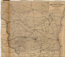
| Description: | This map shows lakes, rivers, railroads, and the soil types of towns and counties. A legend of soil types and conventional signs is included. Relief is sho... |

| Date: | 07 01 1875 |
|---|---|
| Description: | This map shows Lake Ontario, and a portion of Lake Erie and Oneida Lake. Towns surrounding these lakes in Canada and New York are labeled. A key to former ... |

| Date: | 07 01 1876 |
|---|---|
| Description: | This map shows Lake Ontario, and a portion of Lake Erie and Oneida Lake. Towns surrounding these lakes in Canada and New York are labeled. A key to former ... |

| Date: | 07 01 1876 |
|---|---|
| Description: | This map shows towns, railroads, and rivers in Ohio, Michigan, Pennsylvania, New York, and Ontario that surround Lake Erie. A key to completed and uncomple... |

| Date: | 1876 |
|---|---|
| Description: | This map shows eastern Wisconsin, Lake Michigan, western Michigan, northeastern Illinois, and the southern part of Lake Superior. A note is included that r... |

| Date: | 1975 |
|---|---|
| Description: | This map provides an index of quadrangle maps for the state. The lower left corner contains explanation land surveying completeness. Communities, counties,... |

| Date: | 1975 |
|---|---|
| Description: | This map provides an index of outdated quadrangle maps for the state. Communities, counties, rivers, and lakes are labeled including Lake Michigan and Lake... |

| Date: | 1859 |
|---|---|
| Description: | This hand-colored map shows township and range in pink, blue, yellow, and orange, land ownership, includes 16 city inset maps showing land ownership, and 5... |

| Date: | 04 11 1940 |
|---|---|
| Description: | This blue line print map shows survey monument markers by type and industrial buildings and covers part of the lower Fox River and East River. The map incl... |
| Date: | 1879 |
|---|---|
| Description: | This map shows names of triangulation stations, railroads, counties, rivers, and lakes. The Mississippi River, Lake Winnebago, and Lake Michigan are labele... |
| Date: | 1858 |
|---|---|
| Description: | This map shows drainage, acreages, and timber in the area now part of the Town of Shanagolden. The map includes a survey table, a meanders table, and certi... |

| Date: | 1784 |
|---|---|
| Description: | Map showing fifty thousand acres of land in what will later become Kentucky, broken up into parcels labeled 1 through 50. No features are labeled, but the ... |

| Date: | 1880 |
|---|---|
| Description: | A map of Milwaukee which includes a city street guide. |
If you didn't find the material you searched for, our Library Reference Staff can help.
Call our reference desk at 608-264-6535 or email us at: