 Filter: Categories of Wisconsin Historical Images
Filter: Subject of Surveying
Filter: Subject of land
Filter: Creator Name of Unknown
Filter: Categories of Wisconsin Historical Images
Filter: Subject of Surveying
Filter: Subject of land
Filter: Creator Name of Unknown

| Date: | 04 1937 |
|---|---|
| Description: | From back of print: "Dane County, Town of Middleton, north 1/2 section of section 17 looking SW from a hill across the valley showing erosion and stump pas... |
| Date: | |
|---|---|
| Description: | Series 698, General Land Office Survey Plats, vol. 1. |

| Date: | 1874 |
|---|---|
| Description: | Map of New Diggings — inset map in bottom right corner of "Benton & New Diggings" map, on page 11 of "Atlas of Lafayette County Wisconsin," a collect... |

| Date: | 1920 |
|---|---|
| Description: | This map identifies the areas of the state that had been geologically surveyed or topographically surveyed, or both, as well as portions of the state still... |
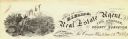
| Date: | |
|---|---|
| Description: | Letterhead of H.I. Bliss, a real estate agent, civil engineer, and county surveyor in La Crosse, Wisconsin. On the left a group of three men are surveying ... |

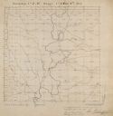
| Date: | 1832 |
|---|---|
| Description: | A hand-drawn map showing the survey of Township number 4, Range number 5, West Fourth Principal Meridian, which is parts of the present day towns of Glen H... |

| Date: | 1873 |
|---|---|
| Description: | This map shows lots and blocks, additions and subdivisions, and large-scale landownership. The map is oriented with north to the upper right. The map is fr... |
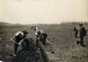
| Date: | |
|---|---|
| Description: | View of a crew surveying land, digging a ditch, and laying drain tile. |
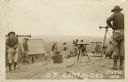
| Date: | |
|---|---|
| Description: | Photographic postcard view of a group of surveyors working on a hilltop at Camp McCoy. Caption reads: "O. P. Camp McCoy, Sparta, Wis." |

| Date: | 09 20 1836 |
|---|---|
| Description: | This map is ink and watercolor on paper and is an unnamed plat. Green Bay is labeled and the plat is labeled "Section 22." One road is labeled "Road to Nav... |

| Date: | 11 1836 |
|---|---|
| Description: | This map is pen-and-ink on paper and is a plat of a paper city on the Wisconsin River, in what is now the Town of Dekorra. The map shows lot and block numb... |

| Date: | 07 01 1876 |
|---|---|
| Description: | This map shows Lake Ontario, and a portion of Lake Erie and Oneida Lake. Towns surrounding these lakes in Canada and New York are labeled. A key to former ... |

| Date: | 07 01 1876 |
|---|---|
| Description: | This map shows towns, railroads, and rivers in Ohio, Michigan, Pennsylvania, New York, and Ontario that surround Lake Erie. A key to completed and uncomple... |
If you didn't find the material you searched for, our Library Reference Staff can help.
Call our reference desk at 608-264-6535 or email us at: