 Filter: Categories of Wisconsin Historical Images
Filter: Subject of Surveying
Filter: Subject of intellectual life
Filter: Categories of Wisconsin Historical Images
Filter: Subject of Surveying
Filter: Subject of intellectual life
| Date: | |
|---|---|
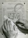
| Description: | Person's hands, one with with wedding ring on left hand, using a ruler, pencil, and protractor to draw a land cover map for Wisconsin Land Economic Invento... |
| Date: | |
|---|---|
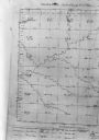
| Description: | Map, "Township No. 22 North, of Range No. 5 West of (?)," surveyed in 1846 and 1853. |
| Date: | 03 16 1950 |
|---|---|
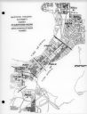
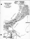
| Description: | Map of areas surveyed by block number as part of the Madison Housing Authority Survey of Substandard Housing. |
| Date: | 03 16 1950 |
|---|---|
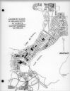
| Description: | Map of locations by block of dwellings rated as blighted as part of the Madison Housing Authority Survey of Substandard Housing. |
| Date: | 03 16 1950 |
|---|---|
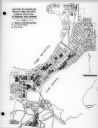
| Description: | Map of locations of blocks of dwellings rated as slums, as part of the Madison Housing Authority Survey of Substandard Housing. |
| Date: | 03 16 1950 |
|---|---|
| Description: | Map of locations by blocks or areas of dwelling units in which violations of ordinance were apparent as part of the Madison Housing Authority Survey of Sub... |

| Date: | 03 16 1950 |
|---|---|
| Description: | A chart showing distribution of 1,148 substandard dwelling units found in the survey area, by basic type of fault, as part of the Madison Housing Authority... |

| Date: | 1920 |
|---|---|
| Description: | This map identifies the areas of the state that had been geologically surveyed or topographically surveyed, or both, as well as portions of the state still... |
| Date: | |
|---|---|
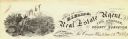
| Description: | Letterhead of H.I. Bliss, a real estate agent, civil engineer, and county surveyor in La Crosse, Wisconsin. On the left a group of three men are surveying ... |

| Date: | |
|---|---|
| Description: | Field notes taken for T6N R17E between 6 and 7 on the original township survey of Wisconsin. |
| Date: | 08 1966 |
|---|---|
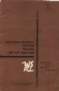
| Description: | Front cover of a report by The Wisconsin Survey Research Laboratory on their public opinion research regarding Wisconsinites' attitudes toward the Vietnam ... |
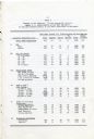
| Date: | 08 1966 |
|---|---|
| Description: | Compiled data regarding attitudes about the United States' involvement in Vietnam in 1966 broken down by gender, age, education level, household income, po... |

| Date: | 07 14 1958 |
|---|---|
| Description: | This is a Tellurometer, a microwave surveying instrument. The operator is Don Reed, field man for Alster and Associates, Washington, D.C., which completed ... |
| Date: | 1882 |
|---|---|
| Description: | Note from Albert Pool, surveyor for the village of Dunbarton in Lafayette County, as appears on the reverse of the Village of Dunbarton plat map. Pool cert... |

| Date: | 11 1836 |
|---|---|
| Description: | This map is pen-and-ink on paper and is a plat of a paper city on the Wisconsin River, in what is now the Town of Dekorra. The map shows lot and block numb... |

| Date: | 1930 |
|---|---|
| Description: | Original map made with watercolor and inkwash. Includes a legend of buildings, roads, natural features and other details of the lodge. Inset at bottom has ... |

| Date: | 1784 |
|---|---|
| Description: | Map showing fifty thousand acres of land in what will later become Kentucky, broken up into parcels labeled 1 through 50. No features are labeled, but the ... |

| Date: | 1850 |
|---|---|
| Description: | Diagrams of four effigy mounds surveyed by Increase A. Lapham and W.H. Canfield in 1850. No. 1 is an unidentified animal shape, No. 2 consists of two linea... |
If you didn't find the material you searched for, our Library Reference Staff can help.
Call our reference desk at 608-264-6535 or email us at: