 Filter: Categories of Wisconsin Historical Images
Filter: Subject of Surveying
Filter: Subject of arts
Filter: Categories of Wisconsin Historical Images
Filter: Subject of Surveying
Filter: Subject of arts
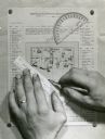
| Date: | |
|---|---|
| Description: | Person's hands, one with with wedding ring on left hand, using a ruler, pencil, and protractor to draw a land cover map for Wisconsin Land Economic Invento... |
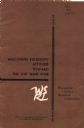
| Date: | 08 1966 |
|---|---|
| Description: | Front cover of a report by The Wisconsin Survey Research Laboratory on their public opinion research regarding Wisconsinites' attitudes toward the Vietnam ... |

| Date: | 1882 |
|---|---|
| Description: | Plat map of the village of Dunbarton, received by the Lafayette County Register's Office on September 22, 1892. Certification by the surveyor, Albert Pool,... |

| Date: | 1930 |
|---|---|
| Description: | Original map made with watercolor and inkwash. Includes a legend of buildings, roads, natural features and other details of the lodge. Inset at bottom has ... |

| Date: | 1919 |
|---|---|
| Description: | Surveyor's drawings of William Deerings Agricultural Works in Lake View, Illinois erected in 1880. |
If you didn't find the material you searched for, our Library Reference Staff can help.
Call our reference desk at 608-264-6535 or email us at: