 Filter: Categories of Wisconsin Historical Images
Filter: Subject of Surveying
Filter: County of Brown
Filter: Creator Name of Unknown
Filter: Categories of Wisconsin Historical Images
Filter: Subject of Surveying
Filter: County of Brown
Filter: Creator Name of Unknown
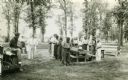
| Date: | 1937 |
|---|---|
| Description: | Probably Native Americans receiving instructions on compass use for Wisconsin Land Economic Inventory. |

| Date: | 09 20 1836 |
|---|---|
| Description: | This map is ink and watercolor on paper and is an unnamed plat. Green Bay is labeled and the plat is labeled "Section 22." One road is labeled "Road to Nav... |
If you didn't find the material you searched for, our Library Reference Staff can help.
Call our reference desk at 608-264-6535 or email us at: