 Filter: Categories of Wisconsin Historical Images
Filter: Subject of Superior, Lake
Filter: Categories of Wisconsin Historical Images
Filter: Subject of Superior, Lake
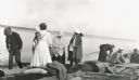
| Date: | 08 22 1916 |
|---|---|
| Description: | Group setting up for a picnic at the shoreline on Bear Island of the Apostle Islands. Image includes A.G. Hull, Elizabeth Nisbet (Mrs. S.C. Marty Sr.), Eli... |
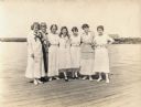
| Date: | |
|---|---|
| Description: | Seven teenage girls posing on a dock on on one of the Apostle Islands. |
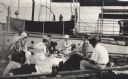
| Date: | |
|---|---|
| Description: | Group having a picnic on the shore of an Apostle Island. There is a large sailboat behind the group. |
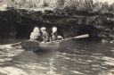
| Date: | |
|---|---|
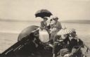
| Description: | Man in a rowboat with two women along the shoreline of Lake Superior. |
| Date: | 1917 |
|---|---|
| Description: | Ladies on the "Gee Whiz" using umbrellas as sun protection. |
| Date: | 1917 |
|---|---|
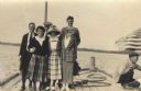
| Description: | Group of men and women standing on Basswood Island Dock. Bill Baker, Elizabeth Hull, Florence Baker, Dorothy Stickney Ross, Louise Baker, Hamilton N. Ross ... |
| Date: | 1910 |
|---|---|
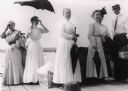
| Description: | Five ladies and one man standing on Old Mission Dock holding picnic baskets and umbrellas. The ladies with umbrellas are from left: Mrs. Ross, Mrs. Ervine,... |
| Date: | 1910 |
|---|---|
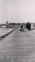
| Description: | Mrs. Lathrop, the town post mistress, pushing her wheelbarrow down a long wooden dock at La Pointe. She is on her way to haul merchandise for her store. |

| Date: | |
|---|---|
| Description: | Map reads: "Historic and Scenic Wisconsin — Land of Gathering Waters." In an inset there is a hand-painted depiction of the Wisconsin State Seal. For some ... |
| Date: | 1928 |
|---|---|
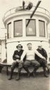
| Description: | Three men posed on the "Madeline." This is a Canadian trip hosted by Henry Woods. |

| Date: | 1930 |
|---|---|
| Description: | Large group of fishermen standing on ice with catch of fish displayed on airplane wing near La Pointe, Madeline Island. |
| Date: | |
|---|---|
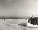
| Description: | George Harris and other ice fishing shanties on Chequamegon Bay. One man is on skis moving across the snow and ice. |

| Date: | 1861 |
|---|---|
| Description: | A map of Wisconsin showing cities, counties, major roads, railroads, and bodies of water. Includes an inset of the vicinity of Milwaukee. |

| Date: | 1872 |
|---|---|
| Description: | Map entitled Office Wallbridge Bro. U. Sargent showing upper Minnesota and Wisconsin, as well as Lake Superior. |

| Date: | 1849 |
|---|---|
| Description: | Geological map of the mineral region around Lake Superior, including portions of Michigan, Wisconsin, Iowa and Illinois. |

| Date: | 1851 |
|---|---|
| Description: | Map of the Lake Superior region showing the railroad and steamboat connection. |

| Date: | 1858 |
|---|---|
| Description: | Map of the Lake Superior region showing the railroad and steamboat connections. |
| Date: | |
|---|---|
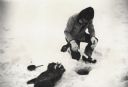
| Description: | Man ice fishing on Chequamegon Bay through a hole with a fishing jig, fish and fry pan. |
| Date: | |
|---|---|
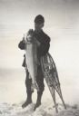
| Description: | Fisherman standing on frozen Lake Superior holding a lake trout, leaning on snowshoes. |
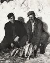
| Date: | 1950 |
|---|---|
| Description: | Vern Frechette (left) and Leonard Larson show their catch of trout caught during ice fishing on Chequamegon Bay. |
If you didn't find the material you searched for, our Library Reference Staff can help.
Call our reference desk at 608-264-6535 or email us at: