 Filter: Categories of Wisconsin Historical Images
Filter: Subject of Superior, Lake
Filter: Year of 1900-1999
Filter: Year of 1920-1929
Filter: Categories of Wisconsin Historical Images
Filter: Subject of Superior, Lake
Filter: Year of 1900-1999
Filter: Year of 1920-1929
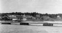
| Date: | 1920 |
|---|---|
| Description: | View from the water of the Mission, dock, Mission cottages, and Congregational Church on Madeline Island. |
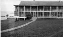
| Date: | 1920 |
|---|---|
| Description: | View across lawn of the Mission Inn on Madeline Island, with a shoreline on the left. |
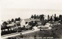
| Date: | 1925 |
|---|---|
| Description: | Aerial view of Woods' Manor on shores of Madeline Island. The manor was built in 1900 for summer resident Colonel Frederick Woods from Nebraska. |
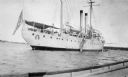
| Date: | 1920 |
|---|---|
| Description: | View from boat of the Coast Guard ship at La Pointe. A shoreline is in the far background. |

| Date: | 1929 |
|---|---|
| Description: | View of an ore dock on Chequamegon Bay. Buildings on the shore of the bay can be seen, however, not the water. |

| Date: | 1920 |
|---|---|
| Description: | Caption reads: "Mammoth Ore Docks, Ashland, Wis." A building and roads are in the foreground. Several ore ships can be seen. |

| Date: | 1920 |
|---|---|
| Description: | Elevated view of the harbor. Caption reads: "The Harbor, Superior, Wis." |
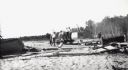
| Date: | 08 29 1922 |
|---|---|
| Description: | Men and boys are on a hand-pump rail cart on a Michigan Island beach, Lake Superior. A young girl is walking on the right. |
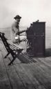
| Date: | 1920 |
|---|---|
| Description: | Leo Capser, founder of the Madeline Island Historical Museum, sitting on a bench playing piano on the Old Mission Dock at Madeline Island. |
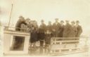
| Date: | 1920 |
|---|---|
| Description: | Group of people standing on board a passenger ferry bound for a New Year's trip to Ashland. |
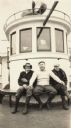
| Date: | 1928 |
|---|---|
| Description: | Three men posed on the "Madeline." This is a Canadian trip hosted by Henry Woods. |
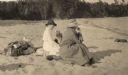
| Date: | 1920 |
|---|---|
| Description: | Mrs. Cora Hull & Mrs. Julia Wood are seated on the sandy shore of one of the Apostle Islands overlooking Lake Superior. |

| Date: | 1925 |
|---|---|
| Description: | This map shows state trunk highways, county trunk highways, railroads, canoe trails, lakes, and free public camp sites. The map on the reverse also shows a... |

| Date: | 1928 |
|---|---|
| Description: | This map shows geological formations throughout Wisconsin. Lakes and rivers are labeled, including The Mississippi River, Lake Superior, and Lake Michigan.... |

| Date: | 1920 |
|---|---|
| Description: | Shows 10 land and water trails along rivers and other bodies of water in northern Wisconsin and the Upper Peninsula of Michigan; each trail numbered and de... |

| Date: | 1928 |
|---|---|
| Description: | Map of portions of Wisconsin and Minnesota between Lake Superior and Mississippi River, showing railroads and military road. |

| Date: | 1923 |
|---|---|
| Description: | This map shows trails, some in red, for automobiles. The right margin includes a key of markings as well as Minnesota and Wisconsin Highway signs. Communit... |

| Date: | 1929 |
|---|---|
| Description: | "Compliments of the Douglas County Highway Department"--Top margin. Shows state-trunk highways, county highways, town roads, trails, boundaries, and concr... |

| Date: | 1925 |
|---|---|
| Description: | This map of Howard's Bay located at the Duluth Superior Harbor is a close view of Connors Point and shows a key to prevailing winds and water depth measure... |

| Date: | 06 1923 |
|---|---|
| Description: | Sanborn map of Ashland, which includes Chequamegon Bay. |
If you didn't find the material you searched for, our Library Reference Staff can help.
Call our reference desk at 608-264-6535 or email us at: