 Filter: Categories of Wisconsin Historical Images
Filter: Subject of Superior, Lake
Filter: Year of 1900-1999
Filter: Subject of cities and towns
Filter: Categories of Wisconsin Historical Images
Filter: Subject of Superior, Lake
Filter: Year of 1900-1999
Filter: Subject of cities and towns
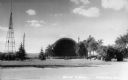
| Date: | 1935 |
|---|---|
| Description: | View of the Ashland Band Shell with benches, trees, and what is today Highway 2 in the foreground. On the left is a large metal tower, and in the backgroun... |

| Date: | 1916 |
|---|---|
| Description: | A pen on paper, hand-drawn map that shows the railroads, rivers, county outlines, and cities and villages in Wisconsin, northern Illinois, and the western ... |

| Date: | 1914 |
|---|---|
| Description: | A business atlas map of Wisconsin, showing the railroads, counties, cities, villages, rivers, lakes, electric lines, and steamship lines in the state. Othe... |

| Date: | 1915 |
|---|---|
| Description: | A map showing the location of post offices in Wisconsin and Michigan that were in operation as of April, 1915, along with the mail routes in use as well as... |

| Date: | 1931 |
|---|---|
| Description: | This U.S. Geological Survey map of Wisconsin shows counties, cities and villages, lighthouses, Indian reservations, military reservations, and bird and gam... |

| Date: | 1933 |
|---|---|
| Description: | This map of Wisconsin and eastern Minnesota identifies federal and state highways in the area. Railroads are shown with the mileage between stops indicated... |

| Date: | 1936 |
|---|---|
| Description: | This pictorial tourist map from the Wisconsin Conservation Commission depicts vacation activities and identifies tourist destinations throughout the state.... |

| Date: | 1941 |
|---|---|
| Description: | Wisconsin counties, towns, cities, and selected villages, as well as the Menominee Indian Reservation are identified on this U.S. Bureau of the Census map ... |

| Date: | 1944 |
|---|---|
| Description: | This nine-part map from the U.S. Bureau of Public Roads identifies federal and state highways in Wisconsin by pavement type. County, forest, park, and publ... |

| Date: | 1950 |
|---|---|
| Description: | This road map shows federal, state and county roads in Wisconsin, northern Illinois, northeastern Iowa, eastern Minnesota, and the western portion of Michi... |

| Date: | 1969 |
|---|---|
| Description: | This Post Office Department map identifies post offices, summer post offices, rural stations, highway post offices, Post Office sectional centers, rural de... |

| Date: | 1910 |
|---|---|
| Description: | This map shows railroads, counties, cities and villages, rivers, lakes, and electric lines are shown in Wisconsin, the western portion of Michigan's Upper ... |

| Date: | 1911 |
|---|---|
| Description: | This map of Wisconsin, the western portion of Michigan's Upper Peninsula, and northern Illinois shows counties, towns, cities and villages, rivers and lake... |

| Date: | 1912 |
|---|---|
| Description: | This map from the U.S. General Land Office shows railroads, counties, cities and villages, rivers, lakes, U.S. Land Offices, Indian reservations, military ... |

| Date: | 1912 |
|---|---|
| Description: | This map is pen, ink, and pencil on tracing paper. The map was traced from U.S. Geological Survey map of Wisconsin, compiled in 1910-1911, and printed in 1... |

| Date: | 1906 |
|---|---|
| Description: | A hand-colored map of Wisconsin identifying the railroads, counties, cities, rivers, and lakes in Wisconsin, eastern Minnesota and Iowa, northern Illinois,... |

| Date: | 1906 |
|---|---|
| Description: | A commercial map of Wisconsin showing the location of creameries and cheese factories in the state. In the lower portion of the map provides the number of ... |

| Date: | 1932 |
|---|---|
| Description: | A map of Iron County, Wisconsin, shows towns and sections, lakes and streams, villages, railroads, roads, and La Point and Lac Du Flambeau Indian reservati... |

| Date: | 1908 |
|---|---|
| Description: | A detailed map of Michigan Island and Gull Island in the Apostle Islands group (T51N, R1W, 4 M) that shows sections, landowners, the Michigan Island Lighth... |
If you didn't find the material you searched for, our Library Reference Staff can help.
Call our reference desk at 608-264-6535 or email us at:
