 Filter: Categories of Wisconsin Historical Images
Filter: Subject of Superior, Lake
Filter: Year of 1900-1999
Filter: Community of Washburn
Filter: Categories of Wisconsin Historical Images
Filter: Subject of Superior, Lake
Filter: Year of 1900-1999
Filter: Community of Washburn

| Date: | 1910 |
|---|---|
| Description: | Bird's-eye view looking east, with Washburn Harbor at center and Chequamegon Bay in Lake Superior covering most of the upper image. Streets with buildings... |
| Date: | 1942 |
|---|---|
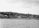
| Description: | View from Lake Superior looking at the shoreline of Washburn. Houses, buildings, people, cars and trees are visible on shore. |
| Date: | 1932 |
|---|---|
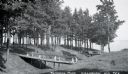
| Description: | View of two wooden foot bridges in Memorial Park. In the background are the waters of Chequamegon Bay in Lake Superior. Picnic tables are among the trees. ... |
| Date: | 1935 |
|---|---|
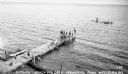
| Description: | Boys and girls wearing bathing suits standing, swimming, or diving off of a large wooden dock into Chequamegon Bay, Lake Superior on the beach at Memorial ... |
| Date: | 1936 |
|---|---|
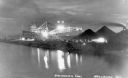
| Description: | Unloading coal from a large ship in Lake Superior onto land near Washburn. There is a large conveyor that has lights glowing in the dark sky. A large pile ... |

| Date: | 1918 |
|---|---|
| Description: | Manuscript map of the Chequamegon Bay area on Lake Superior drawn by Warren W. Witmer and illustrated with sketches by Mary L. Wright Witmer in ink and wat... |
If you didn't find the material you searched for, our Library Reference Staff can help.
Call our reference desk at 608-264-6535 or email us at: