 Filter: Categories of Wisconsin Historical Images
Filter: Subject of Superior, Lake
Filter: Year of 1900-1999
Filter: Type of Map or Atlas
Filter: Categories of Wisconsin Historical Images
Filter: Subject of Superior, Lake
Filter: Year of 1900-1999
Filter: Type of Map or Atlas

| Date: | 1926 |
|---|---|
| Description: | This map shows road surfacings, camp sites, state parks, proposed state parks, rivers, lakes, county boundaries, and cities. Includes portions of Minnesota... |
| Date: | 1926 |
|---|---|
| Description: | This map shows paved roads, highways, road distances, cities, lakes, rivers, and county boundaries. Included are portions of Minnesota, Iowa, and Michigan.... |

| Date: | 1928 |
|---|---|
| Description: | This map shows county boundaries, cities, rivers, lakes, roads and points of interest. Included are portions of Minnesota, Iowa, Illinois, and Michigan. La... |

| Date: | 1928 |
|---|---|
| Description: | This map shows roads, cities, lakes, rivers, points of interest and county boundaries. Through routes are outlined in red. Includes an index to cities and ... |
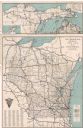
| Date: | 1928 |
|---|---|
| Description: | This map shows U.S., state, county highways, cities, county boundaries, lakes, rivers, and points of interest. At the top of the map it shows the Upper Mic... |

| Date: | 1928 |
|---|---|
| Description: | This map shows roadways, cities, rivers, and lakes. Included are portions of Minnesota, Iowa, and Illinois. Lake Michigan is on the far left side, with Lak... |
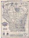
| Date: | 1930 |
|---|---|
| Description: | This map shows types of roadways, cities, lakes, rivers, county boundaries and points of interest. Included are portions of Minnesota, Iowa, Illinois, and ... |
| Date: | 1990 |
|---|---|
| Description: | This map shows Wisconsin Central Ltd. main track, lines out of service, abandoned lines, and trackage rights. The map covers Wisconsin and Michigan's upper... |

| Date: | 1930 |
|---|---|
| Description: | This map shows county boundaries, roads, cities, highways, points of interest, and the locations of Standard Oil Company Service Stations. Included are por... |
| Date: | 1929 |
|---|---|
| Description: | This map shows county boundaries, roads, highways, cities, rivers, lakes, and points of interest. Caption reads: "Compliments of Hotel Warren, Baraboo, Wis... |
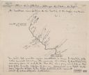
| Date: | 1920 |
|---|---|
| Description: | This map shows a sketch of of the Montreal Rivers and points of interest along the waterway. Includes manuscripts notes in the top and bottom margins. Lake... |

| Date: | 1920 |
|---|---|
| Description: | This map shows the range of hills crossed by Portage. Also shows the location of sandstone, conglomerate rocks, and the Portage trail. Includes manuscript ... |

| Date: | 1957 |
|---|---|
| Description: | This map shows the straights and rivers that connect the Great Lakes, as well as the proposed channels that have been authorized but not at the time of the... |

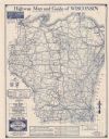
| Date: | 1933 |
|---|---|
| Description: | A road map of Wisconsin, that shows the major and some minor roads of the state, population of the cities and towns, a scale and an index. The reverse side... |

| Date: | 1934 |
|---|---|
| Description: | This map features a road map with a legend and scale. The bigger cities and towns are highlighted in green. The back of the map includes an index, advertis... |

| Date: | 1934 |
|---|---|
| Description: | A road map of Wisconsin sponsored by Conoco. The front side includes and index, scale, and legend. The reverse side includes United States road map, and i... |

| Date: | 1934 |
|---|---|
| Description: | Road map of Wisconsin compliments of Phillips Petroleum Company. The front side includes an index and scale. The reverse side shows a generic road map of t... |

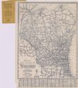
| Date: | 1928 |
|---|---|
| Description: | A Wisconsin state highway map, featuring the major highways, rivers, lakes, and cities. There are a few advertisements on the front and back. The back also... |

| Date: | 1906 |
|---|---|
| Description: | This map shows the cities, counties (outlined in yellow and labeled), rivers, lakes, and the major highways and freeways of Wisconsin and parts of the surr... |

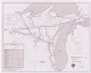
| Date: | 1924 |
|---|---|
| Description: | This map shows railroads, electric lines, and steamship lines. The left margin includes an index of principal cities, and the lower left corner includes a... |
If you didn't find the material you searched for, our Library Reference Staff can help.
Call our reference desk at 608-264-6535 or email us at: