 Filter: Categories of Wisconsin Historical Images
Filter: Subject of Superior, Lake
Filter: Year of 1800-1899
Filter: Year of 1880-1889
Filter: Categories of Wisconsin Historical Images
Filter: Subject of Superior, Lake
Filter: Year of 1800-1899
Filter: Year of 1880-1889

| Date: | 1886 |
|---|---|
| Description: | Bird's-eye view of Ashland, on the shores of Lake Superior, with insets of The Apostle Islands Chequamagon Bay & Ashland, and Distances from Ashland. |

| Date: | 1886 |
|---|---|
| Description: | This map shows U.S. land offices, completed railroads, railroad land grant limits, lakes, rivers, and Indian reservations. Communities, lakes, and rivers a... |
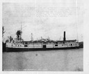
| Date: | 1880 |
|---|---|
| Description: | The screw passenger and freight vessel, Manistee. Faint typing on picture describes the loss of the Manistee on November 16, 1883. The ship <... |

| Date: | 1886 |
|---|---|
| Description: | Bird's-eye view of Bayfield, county seat of Bayfield County. On the lower left side is an inset for Bayfield and the Apostle Islands. |

| Date: | 1883 |
|---|---|
| Description: | Bird's-eye map of Superior, county seat of Douglas County, on the shores of Lake Superior, with insets of points of interest. |

| Date: | 1886 |
|---|---|
| Description: | Bird's-eye map of Washburn on Lake Superior. There is an inset of Washburn, Chequamagon and the Apostle Islands. |

| Date: | 1887 |
|---|---|
| Description: | Bird's-eye view of Superior, on Lake Superior. |

| Date: | 02 26 1887 |
|---|---|
| Description: | Bird's-eye map of Ashland, and the Apostle Islands in Lake Superior. Caption reads: "Ashland and the Apostle Islands." |

| Date: | 1884 |
|---|---|
| Description: | Panorama bird's-eye view of the town of Ashland, on Lake Superior, and the Apostle Islands. |

| Date: | 1885 |
|---|---|
| Description: | View of the ore dock of the Milwaukee, Lake Shore, and Western Railroad. Large logs, buildings and a railroad bridge are in the foreground. |

| Date: | 1885 |
|---|---|
| Description: | Illustrated view of Superior, as well as Omaha, Kansas City, St. Paul, and Winnipeg. Caption reads: "Superior - The Last Possible Great Marine City in the ... |

| Date: | 1880 |
|---|---|
| Description: | This map shows railroads by operator and projected railroads. Portions of Lake Michigan, Lake Superior, Illinois, Iowa, Michigan and Minnesota are labeled. |

| Date: | 1882 |
|---|---|
| Description: | This basic reference map of the state shows natural features, railroads, county seats, and political boundaries against the G.L.O. township and range grid.... |

| Date: | 1887 |
|---|---|
| Description: | Benedict & Co. engineers. As shown by development to March 1st 1887. Inset: Map of northern Wisconsin showing location of range. Lands in red. |

| Date: | 1884 |
|---|---|
| Description: | The official railroad map of Wisconsin showing railroad lines throughout the state. |
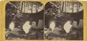
| Date: | 1885 |
|---|---|
| Description: | Stereograph of a sailboat in Excursion Cave, on Hemlock Island of the Apostle Islands. A man can be seen sitting in the boat. |

| Date: | 1881 |
|---|---|
| Description: | A hand-colored map of Wisconsin that shows counties, cities, towns, villages, railroads, as well as the locations of railroad stations and post offices wit... |

| Date: | 1880 |
|---|---|
| Description: | Map of Wisconsin including the eastern portions on Minnesota, Iowa, northern Illinois, and the western most portion of Michigan’s Upper Peninsula, showing ... |

| Date: | 1881 |
|---|---|
| Description: | A brochure with a map of Wisconsin that also includes information (in English, German, Norwegian, and Swedish) pertaining to the state, such as its timber ... |

| Date: | 1882 |
|---|---|
| Description: | A geological map of northern Wisconsin showing the locations of different soil types in the state such as sandy soil, sandy loam, prairie loam, clayey loam... |
If you didn't find the material you searched for, our Library Reference Staff can help.
Call our reference desk at 608-264-6535 or email us at: