 Filter: Categories of Wisconsin Historical Images
Filter: Subject of Superior, Lake
Filter: Year of 1800-1899
Filter: Year of 1830-1839
Filter: Categories of Wisconsin Historical Images
Filter: Subject of Superior, Lake
Filter: Year of 1800-1899
Filter: Year of 1830-1839
| Date: | 1838 |
|---|---|
| Description: | Map of the entire territories of Iowa and Wisconsin. |

| Date: | 1839 |
|---|---|
| Description: | Wisconsin was considered part of Michigan Territory until 1836, a year before Michigan entered statehood. Drawn in 1839, this map shows the state of Michig... |

| Date: | 1834 |
|---|---|
| Description: | This copy of an 1834 map in the American Fur Company's papers held by the New-York Historical Society shows an outline of Chequamegon Bay and Madeline Isla... |

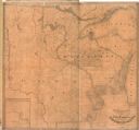
| Date: | 1838 |
|---|---|
| Description: | A color map of the settled part of Wisconsin Territory in 1838, including an inset map of the "Entire Territory of Wisconsin as Established by Act of Congr... |

| Date: | 1836 |
|---|---|
| Description: | This map was created to accompany a congressional report shows the then Wisconsin Territory, including present-day states of Wisconsin, Minnesota, Iowa, an... |

| Date: | 1831 |
|---|---|
| Description: | This map shows the land that makes up Michigan, Wisconsin, Minnesota, Indiana, and parts of Canada. The Great Lakes are displayed prominently, along with s... |
If you didn't find the material you searched for, our Library Reference Staff can help.
Call our reference desk at 608-264-6535 or email us at: