 Filter: Categories of Wisconsin Historical Images
Filter: Subject of Superior, Lake
Filter: Year of 1800-1899
Filter: Creator Name of Unknown
Filter: Categories of Wisconsin Historical Images
Filter: Subject of Superior, Lake
Filter: Year of 1800-1899
Filter: Creator Name of Unknown
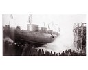
| Date: | 04 1893 |
|---|---|
| Description: | Launching Captain Abe McDougall's whaleback boat, "Christopher Columbus", from the American Steel Barge Company dock. |

| Date: | 1823 |
|---|---|
| Description: | In 1823 U.S. Army major Stephen H. Long led an expedition of scientific, trade, and military investigation up the Mississippi River and the Red River of th... |

| Date: | 1852 |
|---|---|
| Description: | Illustration of four Indians on Madeline Island with a canoe in the water on the shore. |
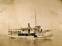
| Date: | 1895 |
|---|---|
| Description: | Captain F.A. Bishoff and engineer Dan Cook on board the ferry "Plowboy." |
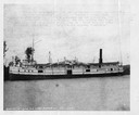
| Date: | 1880 |
|---|---|
| Description: | The screw passenger and freight vessel, Manistee. Faint typing on picture describes the loss of the Manistee on November 16, 1883. The ship <... |

| Date: | 1890 |
|---|---|
| Description: | Bird's-eye map of West Superior and Superior, with insets of Wright Farm and First Building in Superior. |

| Date: | 02 26 1887 |
|---|---|
| Description: | Bird's-eye map of Ashland, and the Apostle Islands in Lake Superior. Caption reads: "Ashland and the Apostle Islands." |

| Date: | 1814 |
|---|---|
| Description: | Map of the Upper Territories of the United States. |

| Date: | 1885 |
|---|---|
| Description: | Illustrated view of Superior, as well as Omaha, Kansas City, St. Paul, and Winnipeg. Caption reads: "Superior - The Last Possible Great Marine City in the ... |

| Date: | 1842 |
|---|---|
| Description: | American Fur Company with both Mission churches. Sketch purportedly by a Native American youth. Probably an overpainted photographic copy enlargement. Pape... |
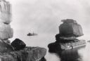
| Date: | 1898 |
|---|---|
| Description: | Rock formation, The Sphinx, on Stockton Island of the Apostle Islands. Steamer "Edna" in background on Lake Superior. |

| Date: | 1872 |
|---|---|
| Description: | Map entitled Office Wallbridge Bro. U. Sargent showing upper Minnesota and Wisconsin, as well as Lake Superior. |

| Date: | 1825 |
|---|---|
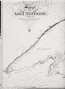
| Description: | Portion of a map showing a survey of Lake Superior including the River St. Louis. |
| Date: | 1825 |
|---|---|
| Description: | Survey of Lake Superior including Wisconsin and Minnesota. |

| Date: | 1863 |
|---|---|
| Description: | Map of the west end of Lake Superior, including Superior, St. Louis, and Allouez Bays. |

| Date: | 1884 |
|---|---|
| Description: | The official railroad map of Wisconsin showing railroad lines throughout the state. |

| Date: | 1878 |
|---|---|
| Description: | A color map detailing Ashland and Bayfield counties, including Lake Superior and the Apostle Islands. |

| Date: | 1856 |
|---|---|
| Description: | A map showing rail lines in Wisconsin and the railroad land grants of the Superior & St. Croix Railroad in the present-day northwestern Wisconsin counties ... |

| Date: | 1890 |
|---|---|
| Description: | A map of Wisconsin, eastern Wisconsin and Iowa, northern Illinois, and the Upper Peninsula of Michigan. The counties, cities and villages, and rail lines i... |

| Date: | 1864 |
|---|---|
| Description: | A geological map of Wisconsin that shows the locations of different rock deposits such as limestone, sandstone, shale, plutonic and the Penokee Iron Range.... |
If you didn't find the material you searched for, our Library Reference Staff can help.
Call our reference desk at 608-264-6535 or email us at: