 Filter: Categories of Wisconsin Historical Images
Filter: Subject of Superior, Lake
Filter: Subject of technology
Filter: Categories of Wisconsin Historical Images
Filter: Subject of Superior, Lake
Filter: Subject of technology

| Date: | 1854 |
|---|---|
| Description: | Drawing of the Porcupine Mountains on Lake Superior. A deer is standing in the lake drinking water. A man is on the rock ledge above the shoreline and is a... |

| Date: | 1913 |
|---|---|
| Description: | Aerial bridge and harbor, with a large boat passing underneath. A lamppost and a beacon are along the walkway towards the bridge on the left. Caption reads... |

| Date: | |
|---|---|
| Description: | Group of six young men and women standing on dock of an Apostle Island. |

| Date: | 1910 |
|---|---|
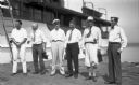
| Description: | Four men aboard the "Lucy" on Lake Superior. Andrew Siem is the boat owner and is operating the tiller. Man with moustache identified as N.J. Ross. |

| Date: | 1979 |
|---|---|
| Description: | Senator Gaylord Nelson, Dave Obey, and Secretary of the Interior Cecil Andrus, walk along a beach with a park ranger during a tour of the Apostle Islands. ... |
| Date: | 1938 |
|---|---|
| Description: | Six men standing on dock next to cabin cruiser "Lamora" on Lake Superior. Two of the men are holding cameras. |

| Date: | 10 21 1855 |
|---|---|
| Description: | Map of the Wisconsin and the Minnesota Territory showing the status of township surveys in Wisconsin and southeastern Minnesota. The Wisconsin reservation... |

| Date: | 1860 |
|---|---|
| Description: | A survey map of Wisconsin, southeastern Minnesota, and northern Iowa, showing the status of surveys, rivers, and lakes. The map also shows the locations of... |

| Date: | 1875 |
|---|---|
| Description: | Map of the triangulations made from Vulcan on the Keweenaw Peninsula in the Upper Peninsula of Michigan south through eastern Wisconsin, past Chicago to Ba... |

| Date: | 1851 |
|---|---|
| Description: | A survey map of Wisconsin and eastern Minnesota, with the township surveys for portions of the Saint Croix region in progress. The maps also show the Meno... |

| Date: | 1855 |
|---|---|
| Description: | This map shows the entire state and part of the Upper Peninsula of Michigan. It depicts creeks, rivers, lakes, railroads completed, railroads in progress, ... |

| Date: | 1857 |
|---|---|
| Description: | This map depicts the township survey grid in Wisconsin, Michigan, northern Illinois, eastern Iowa, and southeastern Minnesota. Counties, named towns, citie... |

| Date: | 1857 |
|---|---|
| Description: | This map shows the township survey grid and identifies counties, named towns, cities and villages, rivers, lakes, and railroads. Boundaries are shown in bl... |

| Date: | 1864 |
|---|---|
| Description: | This map of the entire state of Wisconsin depicts the township survey grid and identifies counties, named towns, cities and villages, rivers, lakes, railro... |
| Date: | |
|---|---|
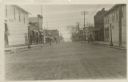
| Description: | View down center of Rittenhouse Avenue with Lake Superior in the distance. The street is lined with businesses, sidewalks and lampposts. |
| Date: | |
|---|---|
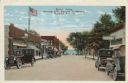
| Description: | Colorized postcard view down a street (Rittenhouse Avenue) to Lake Superior. The street is lined with businesses and parked cars. Caption reads: "Street Sc... |
| Date: | 1950 |
|---|---|
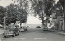
| Description: | Photographic postcard view down Main Street, with Lake Superior in the distance. There is a cafe on the left and bars on the right. Cars are parked along t... |
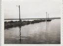
| Date: | 09 14 1962 |
|---|---|
| Description: | View across water towards jetty and dock, with three lampposts, from south east. |

| Date: | 1876 |
|---|---|
| Description: | This map shows eastern Wisconsin, Lake Michigan, western Michigan, northeastern Illinois, and the southern part of Lake Superior. A note is included that r... |

| Date: | 1975 |
|---|---|
| Description: | This map provides an index of quadrangle maps for the state. The lower left corner contains explanation land surveying completeness. Communities, counties,... |
If you didn't find the material you searched for, our Library Reference Staff can help.
Call our reference desk at 608-264-6535 or email us at: