 Filter: Categories of Wisconsin Historical Images
Filter: Subject of Superior, Lake
Filter: Subject of service industries
Filter: Categories of Wisconsin Historical Images
Filter: Subject of Superior, Lake
Filter: Subject of service industries
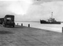
| Date: | 1949 |
|---|---|
| Description: | View from dock of the U.S. Coast Guard ship "Woodrush" arriving at the La Pointe dock to clear ice. Two trucks are on the dock, one with a piano. |
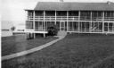
| Date: | 1920 |
|---|---|
| Description: | View across lawn of the Mission Inn on Madeline Island, with a shoreline on the left. |

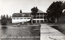
| Date: | 1900 |
|---|---|
| Description: | View of La Pointe, Madeline Island, taken from the Mission Inn. |

| Date: | 1898 |
|---|---|
| Description: | Old Mission Residence at La Pointe, Madeline Island. |

| Date: | 1883 |
|---|---|
| Description: | Bird's-eye map of Superior, county seat of Douglas County, on the shores of Lake Superior, with insets of points of interest. |

| Date: | 1896 |
|---|---|
| Description: | Bird's-eye view of Washburn, with twenty vignettes around side, water in foreground with docks and lumber corral. Thirty-three locations identified in key ... |
| Date: | 1937 |
|---|---|
| Description: | Old Mission Inn on shoreline of Lake Superior, taken from end of dock. The Old Mission Inn was razed in 1965. |
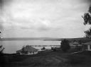
| Date: | |
|---|---|
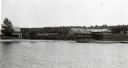
| Description: | View of cottages and Mission dock on Lake Superior on Madeline Island. |
| Date: | 1910 |
|---|---|
| Description: | View from water of the Old Mission Inn on the shore of Lake Superior in La Pointe on Madeline Island. Dwelling to the left is a portion of the lower dormit... |
| Date: | 1910 |
|---|---|
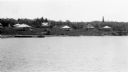
| Description: | View from water of Mission cottages along shoreline of Lake Superior in La Pointe, Madeline Island. |

| Date: | |
|---|---|
| Description: | The Old Mission Inn, originally built as a mission house in 1832 by the Congregational mission established by Frederick Ayer in 1830. In later years furthe... |

| Date: | 1898 |
|---|---|
| Description: | Shows railway lines in Wisconsin marked in red and counties in colors. The meridians are Greenwich, Wisconsin and Washington, Wisconsin. The map folds into... |

| Date: | |
|---|---|
| Description: | Map reads: "Historic and Scenic Wisconsin — Land of Gathering Waters." In an inset there is a hand-painted depiction of the Wisconsin State Seal. For some ... |

| Date: | 1935 |
|---|---|
| Description: | Aerial view of Madeline Island including the tennis courts, houses, and the Old Mission Inn. |

| Date: | 1912 |
|---|---|
| Description: | This map shows parcel zones, counties, electric lines, and railroads. Includes text and charts about parcel post regulations and laws. Also includes an ins... |
| Date: | |
|---|---|
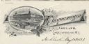
| Description: | Letterhead of the Chequamegon Hotel of Ashland, on Lake Superior, with a three-quarter view of the hotel, as seen from the waterfront, set into a cartouche... |

| Date: | 1914 |
|---|---|
| Description: | Two maps of northern Wisconsin counties of Ashland, Barron, Bayfield, Chippewa, Douglas, Forest, Iron, Langlade, Lincoln, Oneida, Polk, Price, Sawyer, Tayl... |

| Date: | 1855 |
|---|---|
| Description: | This map shows counties, cities, rivers, canals, lakes, railroads, common roads, county towns, townships, villages, and post offices. The map includes part... |

| Date: | 1856 |
|---|---|
| Description: | A hand-colored map of Wisconsin, showing the county boundaries, towns, cities, railroads, roads, lakes, rivers, bays, and the Lake Superior’s islands. In ... |

| Date: | 1881 |
|---|---|
| Description: | A hand-colored map of Wisconsin that shows counties, cities, towns, villages, railroads, as well as the locations of railroad stations and post offices wit... |
If you didn't find the material you searched for, our Library Reference Staff can help.
Call our reference desk at 608-264-6535 or email us at: