 Filter: Categories of Wisconsin Historical Images
Filter: Subject of Superior, Lake
Filter: Subject of resorts
Filter: Categories of Wisconsin Historical Images
Filter: Subject of Superior, Lake
Filter: Subject of resorts
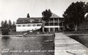
| Date: | 1937 |
|---|---|
| Description: | Old Mission Inn on shoreline of Lake Superior, taken from end of dock. The Old Mission Inn was razed in 1965. |
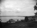
| Date: | |
|---|---|
| Description: | View of cottages and Mission dock on Lake Superior on Madeline Island. |
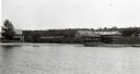
| Date: | 1910 |
|---|---|
| Description: | View from water of the Old Mission Inn on the shore of Lake Superior in La Pointe on Madeline Island. Dwelling to the left is a portion of the lower dormit... |
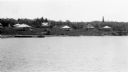
| Date: | 1910 |
|---|---|
| Description: | View from water of Mission cottages along shoreline of Lake Superior in La Pointe, Madeline Island. |
| Date: | |
|---|---|
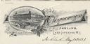
| Description: | Letterhead of the Chequamegon Hotel of Ashland, on Lake Superior, with a three-quarter view of the hotel, as seen from the waterfront, set into a cartouche... |

| Date: | 1914 |
|---|---|
| Description: | Two maps of northern Wisconsin counties of Ashland, Barron, Bayfield, Chippewa, Douglas, Forest, Iron, Langlade, Lincoln, Oneida, Polk, Price, Sawyer, Tayl... |

| Date: | 1950 |
|---|---|
| Description: | This road map shows federal, state and county roads in Wisconsin, northern Illinois, northeastern Iowa, eastern Minnesota, and the western portion of Michi... |

| Date: | 1935 |
|---|---|
| Description: | House, cottages and property of Mrs. J.J. Fisher overlooking Lake Superior. |

| Date: | 1977 |
|---|---|
| Description: | This pictorial map was produced by the Chateau, a resort in La Pointe, and shows Madeline Island landmarks and tourist attractions. On the verso is the spr... |

| Date: | 1926 |
|---|---|
| Description: | This brochure was intended for tourists and shows resorts, lakes and railroads in northwestern Wisconsin and part of Michigan’s upper peninsula. Also inclu... |

| Date: | 1939 |
|---|---|
| Description: | This brochure was intended for tourists and shows resorts, lakes and railroads in northwestern Wisconsin and part of Michigan’s upper peninsula. Also inclu... |

| Date: | 1918 |
|---|---|
| Description: | This map shows counties, cities, towns, villages, summer resorts, lakes, rivers, creeks, wagon roads, roads, railroads, and electric lines. The authentic a... |

| Date: | 1921 |
|---|---|
| Description: | This map shows in red the NorthWestern Railway Line routes running from Chicago, Illinois to northern Wisconsin and Michigan. The map includes cities and t... |

| Date: | 1922 |
|---|---|
| Description: | This map shows in red the NorthWestern Railway Line routes running from Chicago, Illinois to northern Wisconsin. The map includes cities and towns, lakes, ... |

| Date: | |
|---|---|
| Description: | Photographic postcard view of three people on the hillside lift at Chateau Madeleine. Lake Superior is at the bottom of the hill. Text on back reads: "Summ... |
| Date: | |
|---|---|
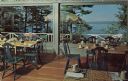
| Description: | Color postcard view of the dining room, with large picture windows, and sundeck, with a view of Lake Superior and the mainland hills in the distance. |
If you didn't find the material you searched for, our Library Reference Staff can help.
Call our reference desk at 608-264-6535 or email us at: