 Filter: Categories of Wisconsin Historical Images
Filter: Subject of Superior, Lake
Filter: Subject of neighborhoods
Filter: Categories of Wisconsin Historical Images
Filter: Subject of Superior, Lake
Filter: Subject of neighborhoods

| Date: | |
|---|---|
| Description: | Looking West from Knight Block, with shipping piers and sailing ships on right side, railroad on left, trees in background. Horse-drawn carriages on street... |
| Date: | 1938 |
|---|---|
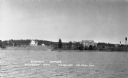
| Description: | Large vacation homes in La Pointe, Madeline Island. Bayfield is in the background on the far shore of Lake Superior. |
| Date: | 1937 |
|---|---|
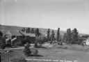
| Description: | View from lake of the summer homes on Nebraska Row along the shoreline of Lake Superior. |
| Date: | 1937 |
|---|---|
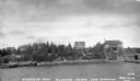
| Description: | View from the lake of the summer homes on Nebraska Row along the shoreline of Lake Superior. The water tower and church steeple are visible on the far righ... |

| Date: | 1863 |
|---|---|
| Description: | This map of Superior shows Montgomery's Addition. An inset map shows the south west end of Lake Superior where Montgomery's Addition is located. The map re... |

| Date: | 1989 |
|---|---|
| Description: | This color coded map shows the various rivers, lakes, bays, and islands that make up the harbor. It includes an index of industries (maritime and non-marit... |
If you didn't find the material you searched for, our Library Reference Staff can help.
Call our reference desk at 608-264-6535 or email us at: