
| Date: | 1900 |
|---|---|
| Description: | A map of Wisconsin, eastern Minnesota and Iowa, northern Iowa, and Michigan’s Upper Peninsula, showing railway lines, with those marked with heavy red line... |

| Date: | 1856 |
|---|---|
| Description: | A map showing rail lines in Wisconsin and the railroad land grants of the Superior & St. Croix Railroad in the present-day northwestern Wisconsin counties ... |

| Date: | 1890 |
|---|---|
| Description: | A map of Wisconsin, eastern Wisconsin and Iowa, northern Illinois, and the Upper Peninsula of Michigan. The counties, cities and villages, and rail lines i... |

| Date: | 1898 |
|---|---|
| Description: | A hand-colored, cloth mounted map of Wisconsin showing the state’s congressional districts. The map also shows the counties, cities, towns, villages, river... |
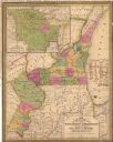
| Date: | 1838 |
|---|---|
| Description: | A color map of the settled part of Wisconsin Territory in 1838, including an inset map of the "Entire Territory of Wisconsin as Established by Act of Congr... |

| Date: | 1899 |
|---|---|
| Description: | This map is a folded insert from the pamphlet "Yesterday and Today : A History." The map features the North-Western Line with labeled railway tracks and st... |

| Date: | 10 15 1956 |
|---|---|
| Description: | This map shows cities with improved harbors along the Great Lakes. A portion of Illinois, Michigan, Ohio, Ontario, and Quebec are also shown. A legend and... |

| Date: | 1890 |
|---|---|
| Description: | This map shows railroad routes, rivers, and lakes throughout the north central states, primarily North and South Dakota, Minnesota, Wisconsin, Illinois, Io... |

| Date: | 1853 |
|---|---|
| Description: | This facsimile map shows counties, towns, and waterways in the state of Wisconsin. Included are portions of Iowa, Michigan, and Minnesota. Lake Superior an... |

| Date: | 1861 |
|---|---|
| Description: | This map shows railroad and other transportation routes in Wisconsin, northern Illinois, the Upper Peninsula of Michigan, portions of Iowa, Minnesota, and ... |

| Date: | 1928 |
|---|---|
| Description: | This blue line map shows the number of carload shipments to northern and central counties, with Mosinee being the central distribution point. Lake Michigan... |
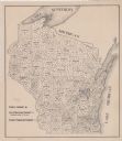
| Date: | 1922 |
|---|---|
| Description: | This map shows public libraries, state traveling libraries, and county traveling libraries. County boundaries are labeled. Lake Michigan is on the far righ... |

| Date: | 1930 |
|---|---|
| Description: | This map shows surface types on the highways including: concrete, bit, mat, gravels, shales, and unsurfaced. County boundaries, cities, rivers, roads, high... |
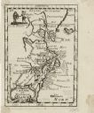
| Date: | 1683 |
|---|---|
| Description: | Map of the north east coast of North America showing islands, regions, Native American land, bays, and a few European settlements. The Great Lakes appear i... |
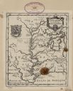
| Date: | 1720 |
|---|---|
| Description: | Map showing the course of the Mississippi River from the Gulf of Mexico up past Lake Superior into Canada. It shows the towns, Native American tribes and l... |
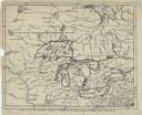
| Date: | 1755 |
|---|---|
| Description: | Map of the Great Lakes region during the French and Indian War. It shows in great detail the territories, borders and boundary lines, Native American tribe... |
If you didn't find the material you searched for, our Library Reference Staff can help.
Call our reference desk at 608-264-6535 or email us at: