 Filter: Categories of Wisconsin Historical Images
Filter: Subject of Superior, Lake
Filter: Subject of land
Filter: Categories of Wisconsin Historical Images
Filter: Subject of Superior, Lake
Filter: Subject of land

| Date: | 1856 |
|---|---|
| Description: | A hand-colored map of Wisconsin, showing the county boundaries, towns, cities, railroads, roads, lakes, rivers, bays, and the Lake Superior’s islands. In ... |

| Date: | 1856 |
|---|---|
| Description: | This map shows the entire state of Wisconsin with counties, cities and rivers. It includes an inset of the layout of the streets of Milwaukee and a chart w... |

| Date: | 1857 |
|---|---|
| Description: | This detailed map was drawn nearly a decade after Wisconsin entered statehood. It depicts the entire state, northern Illinois and part of the upper peninsu... |

| Date: | 1939 |
|---|---|
| Description: | This map shows the towns to Gingles, Sanborn, and Guney as well as Chequamegon Bay, Kakagon River, White River, Marengo River, Bad River, Potato River, Vau... |
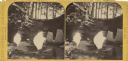
| Date: | 1885 |
|---|---|
| Description: | Stereograph of a sailboat in Excursion Cave, on Hemlock Island of the Apostle Islands. A man can be seen sitting in the boat. |

| Date: | 1864 |
|---|---|
| Description: | A geological map of Wisconsin that shows the locations of different rock deposits such as limestone, sandstone, shale, plutonic and the Penokee Iron Range.... |

| Date: | 1866 |
|---|---|
| Description: | This thematic shows the effects that Lake Michigan has had on Wisconsin mean temperatures in January and July. The map shows counties, some cities, rivers ... |
| Date: | 1938 |
|---|---|
| Description: | Aerial view looking down over the lawn and wood shingle lakeshore home, Woods Manor, a part of Nebraska Row on Madeline Island. In the distance is Lake Sup... |

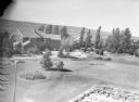
| Date: | 1938 |
|---|---|
| Description: | View of a house on Nebraska Row on Madeline Island. In the foreground is a flag pole, bench, path, lawn and trees. On the left are docks from the lake shor... |

| Date: | 1916 |
|---|---|
| Description: | A pen on paper, hand-drawn map that shows the railroads, rivers, county outlines, and cities and villages in Wisconsin, northern Illinois, and the western ... |

| Date: | 1866 |
|---|---|
| Description: | A pen on paper, hand-drawn and colored map of Wisconsin and Michigan, showing counties, cities and villages, rivers and lakes, as well as railroads are in ... |

| Date: | 1867 |
|---|---|
| Description: | Map of the entire state indicates county boundaries outlined in red, cities of over 3000 inhabitants and county seats. It also marks rivers and lakes. |

| Date: | 1868 |
|---|---|
| Description: | This map of the entire state shows county boundaries outlined in red, cities of over 3000 inhabitants and county seats. It also marks rivers, lakes, railro... |

| Date: | 1868 |
|---|---|
| Description: | Prepared for the State Board of Emigration in 1868, this map shows county boundaries, some cities, and completed and projected railroads. |

| Date: | 1873 |
|---|---|
| Description: | Map of Wisconsin showing counties, county seats, cities with populations over 3,000, and congressional districts. The map also includes rivers, lakes, rail... |

| Date: | 1875 |
|---|---|
| Description: | Map of the triangulations made from Vulcan on the Keweenaw Peninsula in the Upper Peninsula of Michigan south through eastern Wisconsin, past Chicago to Ba... |

| Date: | 1876 |
|---|---|
| Description: | A map of Wisconsin and the western portion of Michigan’s Upper Peninsula showing the township grid, counties, towns, river systems, and lakes. The borders ... |

| Date: | 1879 |
|---|---|
| Description: | A map of Wisconsin as well as the southeastern most portions of Minnesota and Iowa and the Upper Peninsula of Michigan showing the township grids, railways... |

| Date: | 1879 |
|---|---|
| Description: | A map of Wisconsin showing counties, county seats, cities over 3,000 inhabitants, Lake Michigan steamship routes, railroads completed and projected, rivers... |

| Date: | 1881 |
|---|---|
| Description: | A hand-colored map of Wisconsin that shows counties, cities, towns, villages, railroads, as well as the locations of railroad stations and post offices wit... |
If you didn't find the material you searched for, our Library Reference Staff can help.
Call our reference desk at 608-264-6535 or email us at: