 Filter: Categories of Wisconsin Historical Images
Filter: Subject of Superior, Lake
Filter: Subject of land
Filter: Year of 1900-1999
Filter: Year of 1940-1949
Filter: Categories of Wisconsin Historical Images
Filter: Subject of Superior, Lake
Filter: Subject of land
Filter: Year of 1900-1999
Filter: Year of 1940-1949
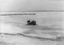
| Date: | 02 1948 |
|---|---|
| Description: | Elevated view of the enclosed wind sled shaped like the Maybe, sitting on the ice with La Pointe dock on the left. |
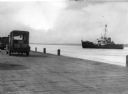
| Date: | 1949 |
|---|---|
| Description: | View from dock of the U.S. Coast Guard ship "Woodrush" arriving at the La Pointe dock to clear ice. Two trucks are on the dock, one with a piano. |
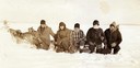
| Date: | 1945 |
|---|---|
| Description: | Mary L. Eldridge, Dick Eldridge, Barney Johnson, and two other people kneeling in front of dog sled on Lake Superior. |

| Date: | 1941 |
|---|---|
| Description: | Official highway map of Wisconsin, "the playground of the Midwest," showing the state transportation network prior to World War II. |
| Date: | 1940 |
|---|---|
| Description: | Lakeside view from pier of large two-story house and grounds on Madeline Island. |

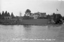
| Date: | 1947 |
|---|---|
| Description: | This map shows the territories of Chippewa, Sioux, Winnebago, and Monomone tribes. It also shows navigation notes for rivers and lakes, Indian villages, hi... |
| Date: | 1940 |
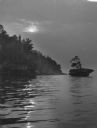
|---|---|
| Description: | The moon, partially obstructed by clouds, is reflected in the waters off one of the Apostle Islands. There is a small islet on the right, with several tree... |
If you didn't find the material you searched for, our Library Reference Staff can help.
Call our reference desk at 608-264-6535 or email us at: