 Filter: Categories of Wisconsin Historical Images
Filter: Subject of Superior, Lake
Filter: Subject of lakes
Filter: Type of Photograph
Filter: Categories of Wisconsin Historical Images
Filter: Subject of Superior, Lake
Filter: Subject of lakes
Filter: Type of Photograph
| Date: | 1671 |
|---|---|
| Description: | Photostat of map of Lac Tracy Ou Superieur (Lake Superior). Portions of Lac des Illinois (Lake Michigan) and Lac des Hurons (Lake Huron) are also shown. Gr... |
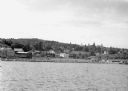
| Date: | 1942 |
|---|---|
| Description: | View from Lake Superior looking at the shoreline of Washburn. Houses, buildings, people, cars and trees are visible on shore. |
| Date: | 1931 |
|---|---|
| Description: | View of the Squaw Bay Caves, near Cornucopia, with people in a boat off to the far left. The caves were renamed Mawikwe Bay, and Mawikwe is Ojibwe for weep... |
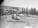
| Date: | 1938 |
|---|---|
| Description: | Aerial view looking down over the lawn and wood shingle lakeshore home, Woods Manor, a part of Nebraska Row on Madeline Island. In the distance is Lake Sup... |
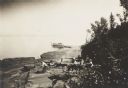
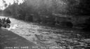
| Date: | 1912 |
|---|---|
| Description: | Picnic party on the rocks along the shore, among the Apostle Islands in Lake Superior. |

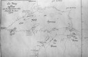
| Date: | 1918 |
|---|---|
| Description: | Manuscript map of the Chequamegon Bay area on Lake Superior drawn by Warren W. Witmer and illustrated with sketches by Mary L. Wright Witmer in ink and wat... |
If you didn't find the material you searched for, our Library Reference Staff can help.
Call our reference desk at 608-264-6535 or email us at: