Filter: Categories of Wisconsin Historical Images
Filter: Subject of Superior, Lake
Filter: Subject of human settlements
Filter: Categories of Wisconsin Historical Images
Filter: Subject of Superior, Lake
Filter: Subject of human settlements

| Date: | 1928 |
|---|---|
| Description: | This map shows geological formations throughout Wisconsin. Lakes and rivers are labeled, including The Mississippi River, Lake Superior, and Lake Michigan.... |
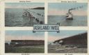
| Date: | 09 19 1932 |
|---|---|
| Description: | Four views near Lake Superior, including two scenes of boats and docks near the ore docks, a bathing scene showing a group of people swimming in the lake a... |

| Date: | 09 24 1910 |
|---|---|
| Description: | View of several fisherman's homes on Bear Island, one of the islands that make up the Apostle Islands. An American flag is flying between buildings and a d... |
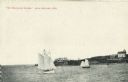
| Date: | |
|---|---|
| Description: | View across water towards two schooners off the shore of Madeline Island, one of the islands that comprise the Apostle Islands in Lake Superior. Two large ... |

| Date: | 1892 |
|---|---|
| Description: | A cloth mounted, hand-colored map of Wisconsin showing the rail routes, counties, cities, towns, rivers and lakes in the state. The map also shows eastern ... |

| Date: | 1930 |
|---|---|
| Description: | This map shows Indian trails through Wisconsin counties. The trail are in red ink. Lake Michigan, Green Bay, Lake Superior, and the Wisconsin River are lab... |

| Date: | 1923 |
|---|---|
| Description: | This map shows trails, some in red, for automobiles. The right margin includes a key of markings as well as Minnesota and Wisconsin Highway signs. Communit... |

| Date: | 1846 |
|---|---|
| Description: | A hand-colored map of Wisconsin shows the counties in the state south and east of the Wisconsin and Fox rivers and the locations of Indian lands to the nor... |

| Date: | 1896 |
|---|---|
| Description: | This hand-colored map shows counties, county seats, cities, towns, proposed and completed railroads, and U.S. Land Offices. Also included in the map are th... |

| Date: | 1895 |
|---|---|
| Description: | A map of Wisconsin that shows the counties, cities, towns, rivers, and lakes of the state, the eastern most portions of Minnesota, Iowa, northern Illinois,... |

| Date: | 1899 |
|---|---|
| Description: | This color map, originally published in the Smithsonian Institution Bureau of American Ethnology's 18th annual report, shows the Indian land cessions in Wi... |

| Date: | 1896 |
|---|---|
| Description: | A map showing the Wisconsin Central Railroad lines in Wisconsin, northern Illinois, eastern Minnesota, and Michigan’s Upper Peninsula. The area of the map ... |

| Date: | 1900 |
|---|---|
| Description: | A map of Wisconsin, eastern Minnesota and Iowa, northern Iowa, and Michigan’s Upper Peninsula, showing railway lines, with those marked with heavy red line... |

| Date: | 1900 |
|---|---|
| Description: | This map, which shows the state of Wisconsin in 1895, was published as Rand, McNally & Co.'s New business atlas map of Wisconsin. Railroads, counties, citi... |

| Date: | 1900 |
|---|---|
| Description: | A map of Wisconsin, eastern Minnesota and Iowa, and Michigan’s Upper Peninsula, showing the rail lines of the Wisconsin Central Railroad are shown in red, ... |

| Date: | 1908 |
|---|---|
| Description: | A business map of Wisconsin, showing railroads, counties, cities, villages, rivers, and lakes. Additional areas shown in the map include the western portio... |

| Date: | 1913 |
|---|---|
| Description: | A hand-colored map of Wisconsin and portions of eastern Iowa and Minnesota, northern Illinois, and the western part of Michigan’s Upper Peninsula, showing ... |

| Date: | 1914 |
|---|---|
| Description: | Two maps of northern Wisconsin counties of Ashland, Barron, Bayfield, Chippewa, Douglas, Forest, Iron, Langlade, Lincoln, Oneida, Polk, Price, Sawyer, Tayl... |

| Date: | 1914 |
|---|---|
| Description: | A hand-colored map of Wisconsin showing the locations of cities and towns, counties, railway lines, the steamship lines in Lake Superior and lake Michigan.... |
If you didn't find the material you searched for, our Library Reference Staff can help.
Call our reference desk at 608-264-6535 or email us at: