 Filter: Categories of Wisconsin Historical Images
Filter: Subject of Superior, Lake
Filter: Subject of human settlements
Filter: Categories of Wisconsin Historical Images
Filter: Subject of Superior, Lake
Filter: Subject of human settlements

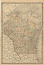
| Date: | 1885 |
|---|---|
| Description: | A hand-colored map of Wisconsin showing the railroads, counties, cities, towns, rivers, and lakes in the state. Also included in the map are the eastern po... |
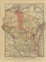
| Date: | 1888 |
|---|---|
| Description: | A cloth mounted, hand-colored map of Wisconsin depicting the rail routes, counties, towns, rivers, and lakes throughout the state. Also included in the ma... |
| Date: | 1889 |
|---|---|
| Description: | A map that shows the railroad's lines in Wisconsin, northern Illinois, and the Upper Peninsula of Michigan. Those that are marked with a red line are those... |

| Date: | |
|---|---|
| Description: | Aerial view of town, showing the shoreline of Lake Superior, ore docks, roads, houses, buildings, trees, and smokestacks. Text describing this photograph s... |

| Date: | 1839 |
|---|---|
| Description: | Wisconsin was considered part of Michigan Territory until 1836, a year before Michigan entered statehood. Drawn in 1839, this map shows the state of Michig... |

| Date: | 1844 |
|---|---|
| Description: | Wisconsin was considered part of Michigan Territory until 1836, a year before Michigan entered statehood. Drawn four years before Wisconsin entered stateho... |

| Date: | 1845 |
|---|---|
| Description: | Wisconsin was considered part of Michigan Territory until 1836, a year before Michigan entered statehood. Drawn three years before Wisconsin entered stateh... |

| Date: | 1858 |
|---|---|
| Description: | Front cover of a guide book describing Bayfield and an account of a pleasure tour to Lake Superior. The title is surrounded by a decorative border with flo... |

| Date: | 1854 |
|---|---|
| Description: | Brightly-colored map exhaustively marks the townships, County Towns and villages of Wisconsin. It also shows rivers, canals, railroads, and plank roads. Ea... |

| Date: | 1854 |
|---|---|
| Description: | This map shows proposed counties in northern Wisconsin included Douglas, La Pointe, Polk, Chippewa, Dunn, St. Croix, Pierce and Clark. This map shows the p... |

| Date: | 1855 |
|---|---|
| Description: | Drawn seven years after Wisconsin entered statehood, this map shows the counties, cities, towns, rivers and lakes in the entire state. The map includes a c... |

| Date: | 1855 |
|---|---|
| Description: | This map shows the entire state and part of the Upper Peninsula of Michigan. It depicts creeks, rivers, lakes, railroads completed, railroads in progress, ... |

| Date: | 1874 |
|---|---|
| Description: | This map shows lands in the vicinity of the railway route between St. Paul and Chicago, extending from Valley Junction (labelled Wisconsin Valley Junction ... |

| Date: | 1874 |
|---|---|
| Description: | This map of Wisconsin shows cities, counties, railroads already completed and railroads projected, and geological makeup of the land such as lakes. |

| Date: | 1914 |
|---|---|
| Description: | A business atlas map of Wisconsin, showing the railroads, counties, cities, villages, rivers, lakes, electric lines, and steamship lines in the state. Othe... |

| Date: | 1915 |
|---|---|
| Description: | A map showing the location of post offices in Wisconsin and Michigan that were in operation as of April, 1915, along with the mail routes in use as well as... |

| Date: | 1931 |
|---|---|
| Description: | This U.S. Geological Survey map of Wisconsin shows counties, cities and villages, lighthouses, Indian reservations, military reservations, and bird and gam... |

| Date: | 1933 |
|---|---|
| Description: | This map of Wisconsin and eastern Minnesota identifies federal and state highways in the area. Railroads are shown with the mileage between stops indicated... |

| Date: | 1936 |
|---|---|
| Description: | This pictorial tourist map from the Wisconsin Conservation Commission depicts vacation activities and identifies tourist destinations throughout the state.... |

| Date: | 1941 |
|---|---|
| Description: | Wisconsin counties, towns, cities, and selected villages, as well as the Menominee Indian Reservation are identified on this U.S. Bureau of the Census map ... |
If you didn't find the material you searched for, our Library Reference Staff can help.
Call our reference desk at 608-264-6535 or email us at: