 Filter: Categories of Wisconsin Historical Images
Filter: Subject of Superior, Lake
Filter: Reproduction Rights of For Sale
Filter: Year of 1800-1899
Filter: Year of 1820-1829
Filter: Categories of Wisconsin Historical Images
Filter: Subject of Superior, Lake
Filter: Reproduction Rights of For Sale
Filter: Year of 1800-1899
Filter: Year of 1820-1829

| Date: | 1823 |
|---|---|
| Description: | In 1823 U.S. Army major Stephen H. Long led an expedition of scientific, trade, and military investigation up the Mississippi River and the Red River of th... |

| Date: | 1821 |
|---|---|
| Description: | Engraving of the Pictured Rocks shoreline viewed from Lake Superior. |

| Date: | 1825 |
|---|---|
| Description: | Portion of a map showing a survey of Lake Superior including the River St. Louis. |
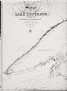
| Date: | 1825 |
|---|---|
| Description: | Survey of Lake Superior including Wisconsin and Minnesota. |

| Date: | 1820 |
|---|---|
| Description: | Map of the Northwestern Territories of the United State showing the track pursued by the Expedition in 1820. |
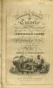
| Date: | 1820 |
|---|---|
| Description: | Narrative Journal of Travels from Detroit Northwest through the Great chain of American Lakes to the sources of the Mississippi River in the year 1820. Ill... |
If you didn't find the material you searched for, our Library Reference Staff can help.
Call our reference desk at 608-264-6535 or email us at: