Filter: Categories of Wisconsin Historical Images
Filter: Subject of Superior, Lake
Filter: Reproduction Rights of For Sale
Filter: Subject of land
Filter: Categories of Wisconsin Historical Images
Filter: Subject of Superior, Lake
Filter: Reproduction Rights of For Sale
Filter: Subject of land
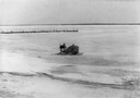
| Date: | 05 1954 |
|---|---|
| Description: | Windsled used to transport passengers and goods between Madeline Island and Bayfield. This image was in Ross' book, "La Pointe: Village Outpost". |
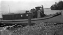
| Date: | 1954 |
|---|---|
| Description: | Elmer Nelson sorting through boxes of goods being transported on the "Dream Sled" windsled. |
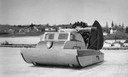
| Date: | 02 1948 |
|---|---|
| Description: | Elevated view of the enclosed wind sled shaped like the Maybe, sitting on the ice with La Pointe dock on the left. |

| Date: | 1898 |
|---|---|
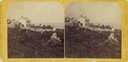
| Description: | Old Mission Residence at La Pointe, Madeline Island. |
| Date: | 1930 |
|---|---|
| Description: | View from water of cottages along the shoreline in Nebraska Row, La Pointe, Madeline Island. Caption reads: "Nebraska Row — La Pointe, Wis." |
| Date: | 1913 |
|---|---|
| Description: | Elevated view of wooden boats at Raspberry Island (or Devils Island) dock with picnickers on shore. The "Lizzie W' and Nelson Angus, A.G. Hull, Elsie Tough... |
| Date: | 1915 |
|---|---|
| Description: | Two women aboard the Hull family boat, the "Lizzie W.," while it is tied to shore at one of the Apostle Islands. |
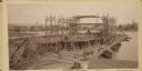
| Date: | 09 19 1892 |
|---|---|
| Description: | Captain Alexander McDougall's whaleback passenger steamer "Christopher Columbus" under construction in the shipyard of the American Steel Barge Company in ... |

| Date: | 1910 |
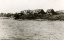
|---|---|
| Description: | Bird's-eye view looking east, with Washburn Harbor at center and Chequamegon Bay in Lake Superior covering most of the upper image. Streets with buildings... |
| Date: | 1671 |
|---|---|
| Description: | Photostat of map of Lac Tracy Ou Superieur (Lake Superior). Portions of Lac des Illinois (Lake Michigan) and Lac des Hurons (Lake Huron) are also shown. Gr... |

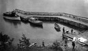
| Date: | 1960 |
|---|---|
| Description: | Aerial view with docks in the foreground. Caption reads: "Superior, Wisconsin." |
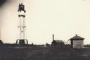
| Date: | |
|---|---|
| Description: | Lighthouse and buildings on Devil's Island of the Apostle Islands. |

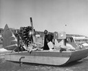
| Date: | 1930 |
|---|---|
| Description: | Large group of fishermen standing on ice with catch of fish displayed on airplane wing near La Pointe, Madeline Island. |
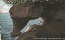
| Date: | |
|---|---|
| Description: | Postcard of the Grand Piano geological formation on Devil's Island. Caption reads: "Apostle Islands, Wis. Devil's Island, the Grand Piano." |
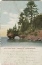
| Date: | |
|---|---|
| Description: | Colorized postcard of the Grand Arch geological formation on Sand Island, part of the Apostle Islands. Caption reads: "Grand Arch, Sand I., Apostle Is., La... |

| Date: | 1895 |
|---|---|
| Description: | A map of Wisconsin that shows the counties, cities, towns, rivers, and lakes of the state, the eastern most portions of Minnesota, Iowa, northern Illinois,... |

| Date: | 1899 |
|---|---|
| Description: | This color map, originally published in the Smithsonian Institution Bureau of American Ethnology's 18th annual report, shows the Indian land cessions in Wi... |

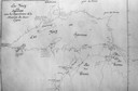
| Date: | 1914 |
|---|---|
| Description: | Two maps of northern Wisconsin counties of Ashland, Barron, Bayfield, Chippewa, Douglas, Forest, Iron, Langlade, Lincoln, Oneida, Polk, Price, Sawyer, Tayl... |

| Date: | 1918 |
|---|---|
| Description: | Map of Wisconsin along with the western portion of Michigan’s Upper Peninsula, showing county lines, cities and villages, lakes, streams, and railroads. Po... |
If you didn't find the material you searched for, our Library Reference Staff can help.
Call our reference desk at 608-264-6535 or email us at: