 Filter: Categories of Wisconsin Historical Images
Filter: Subject of Superior, Lake
Filter: County of Bayfield
Filter: Categories of Wisconsin Historical Images
Filter: Subject of Superior, Lake
Filter: County of Bayfield
| Date: | |
|---|---|
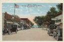
| Description: | Colorized postcard view down a street (Rittenhouse Avenue) to Lake Superior. The street is lined with businesses and parked cars. Caption reads: "Street Sc... |
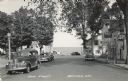
| Date: | 1950 |
|---|---|
| Description: | Photographic postcard view down Main Street, with Lake Superior in the distance. There is a cafe on the left and bars on the right. Cars are parked along t... |
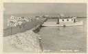
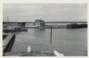
| Date: | 1949 |
|---|---|
| Description: | Photographic postcard view of the City Dock on Lake Superior. There are four boats, and people and cars are on the dock. A sign in the foreground reads: "N... |
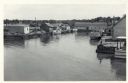
| Date: | |
|---|---|
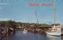
| Description: | Photographic postcard view from water of a marina. Sailboats and motorboats are docked. More boats are stored up on the shoreline. Trees and buildings are ... |

| Date: | |
|---|---|
| Description: | Color postcard of view across water towards the "Nichevo II" ferry for Bayfield-Madeline Island moving through the water and filled with tourists and their... |
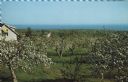
| Date: | |
|---|---|
| Description: | Elevated view of an orchard during apple blossom season, with Lake Superior in the distance. |
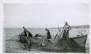
| Date: | |
|---|---|
| Description: | Four fishermen in a boat lift nets on Lake Superior. The far shoreline is in the background. |

| Date: | 1856 |
|---|---|
| Description: | This map of Bayfield shows a plat of the town, roads, and part of Lake Superior. Relief is shown by hachures. The right margin of the map includes illustra... |

| Date: | 1892 |
|---|---|
| Description: | This map of Bayfield shows roads, lots, and township boundaries. The map was originally published on one sheet but is now separated into front and back. On... |

| Date: | |
|---|---|
| Description: | Exterior of the menu for Paul's Cafe, with a bird's-eye view map of "Washburn's Natural Deep Water Land Locked Harbor," Chequamegon Bay, and the Apostle Is... |

| Date: | 1856 |
|---|---|
| Description: | This map shows land ownership by name, a plat of Bayfield, local streets, part of Lake Superior, part of Madeline Island, and part of Bass Island. La Point... |

| Date: | 07 2001 |
|---|---|
| Description: | David Obey poses with Park Ranger Geoffrey Smith on the left and Martin Hanson on the right. They are standing on the beach with water and land in the back... |

| Date: | |
|---|---|
| Description: | Three women stand on the shore in front of the steamer Barker at Devils Island natural dock. |
| Date: | 06 19 1958 |
|---|---|
| Description: | Slightly elevated view of Cornucopia Harbor. There is a boat moored at a pier near a barn-shaped building. An automobile is parked on the far left. In the ... |
| Date: | 06 19 1958 |
|---|---|
| Description: | Slightly elevated view over water towards East slip in Cornucopia Harbor. There is a small cluster of buildings along the left and right sides with boats m... |
| Date: | 06 19 1958 |
|---|---|
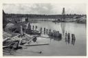
| Description: | View over water towards storm damage in Cornucopia Harbor. West slip. There is a pile of wood along the shoreline in the foreground, with a boat moored jus... |
| Date: | |
|---|---|
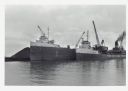
| Description: | View across water towards ships unloading coal and sulphur. Cranes rise above both ships, and a man is walking near a large pile of coal in the background ... |
| Date: | |
|---|---|
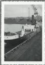
| Description: | Elevated view over railroads tracks of Canadian ship with cargo of wood pulp. Sulphide bales are being unloaded and there are several men on the ship. In t... |
| Date: | |
|---|---|
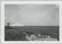
| Description: | View from shoreline of dock site towards Lake Superior, showing sulphur pile and a large chute in the background. |
If you didn't find the material you searched for, our Library Reference Staff can help.
Call our reference desk at 608-264-6535 or email us at:
