 Filter: Categories of Wisconsin Historical Images
Filter: Subject of Superior, Lake
Filter: Community of Ashland
Filter: Categories of Wisconsin Historical Images
Filter: Subject of Superior, Lake
Filter: Community of Ashland

| Date: | |
|---|---|
| Description: | Aerial view of town, showing the shoreline of Lake Superior, ore docks, roads, houses, buildings, trees, and smokestacks. Text describing this photograph s... |

| Date: | 06 1923 |
|---|---|
| Description: | Sanborn map of Ashland, which includes Chequamegon Bay. |
| Date: | 09 14 1962 |
|---|---|
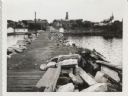
| Description: | View from pier, lined with rocks, towards town. There are industrial buildings along the shoreline, and up a small rise is a building with a tower, and on ... |
| Date: | 09 14 1962 |
|---|---|
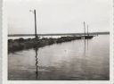
| Description: | View across water towards jetty and dock, with three lampposts, from south east. |
| Date: | 1935 |
|---|---|
| Description: | Aerial view of crew members standing and sitting on the deck of the ore boat Captain Thomas Wilson in Ashland harbor. |
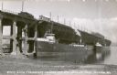
| Date: | 1935 |
|---|---|
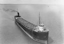
| Description: | View from shoreline towards three ore boats at the Soo Line Railroad dock being loaded with iron ore. The first in line is the William B. Pilkey. |
If you didn't find the material you searched for, our Library Reference Staff can help.
Call our reference desk at 608-264-6535 or email us at: