 Filter: Categories of Wisconsin Historical Images
Filter: Subject of Superior, Lake
Filter: Creator Name of Unknown
Filter: Categories of Wisconsin Historical Images
Filter: Subject of Superior, Lake
Filter: Creator Name of Unknown
| Date: | |
|---|---|
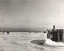
| Description: | George Harris and other ice fishing shanties on Chequamegon Bay. One man is on skis moving across the snow and ice. |

| Date: | 1872 |
|---|---|
| Description: | Map entitled Office Wallbridge Bro. U. Sargent showing upper Minnesota and Wisconsin, as well as Lake Superior. |

| Date: | |
|---|---|
| Description: | Hand-drawn, folded extension of map, rendered on notebook paper. |

| Date: | 1825 |
|---|---|
| Description: | Portion of a map showing a survey of Lake Superior including the River St. Louis. |
| Date: | 1825 |
|---|---|
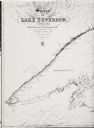
| Description: | Survey of Lake Superior including Wisconsin and Minnesota. |

| Date: | 1863 |
|---|---|
| Description: | Map of the west end of Lake Superior, including Superior, St. Louis, and Allouez Bays. |
| Date: | |
|---|---|
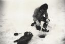
| Description: | Man ice fishing on Chequamegon Bay through a hole with a fishing jig, fish and fry pan. |
| Date: | |
|---|---|
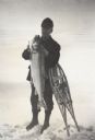
| Description: | Fisherman standing on frozen Lake Superior holding a lake trout, leaning on snowshoes. |
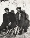
| Date: | 1950 |
|---|---|
| Description: | Vern Frechette (left) and Leonard Larson show their catch of trout caught during ice fishing on Chequamegon Bay. |
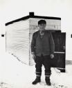
| Date: | |
|---|---|
| Description: | Ice fisherman Bruno Grotzke of Ashland poses in front of his fishing shanty on Chequamegon Bay. |
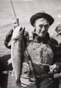
| Date: | |
|---|---|
| Description: | A fisherman sitting in a boat is holding a cigar and posing with lake trout. |
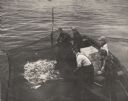
| Date: | 1955 |
|---|---|
| Description: | Three fisherman in a boat pulling in a net full of fish on Chequamegon Bay while a man and a boy look on. |
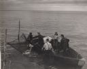
| Date: | 1955 |
|---|---|
| Description: | Four men and a boy netting trout from boat on Chequamegon Bay. |
| Date: | 1955 |
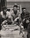
|---|---|
| Description: | Catch of lake trout displayed by three fisherman on the pier at Little Sand Bay. From left to right are Martin Johnson, Hermy Johnson, and Myron Lohman. |
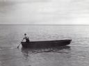
| Date: | |
|---|---|
| Description: | Lone man boating or fishing alone on Lake Superior. He is standing at the rear of the boat holding an oar. |
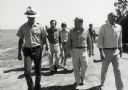
| Date: | 1979 |
|---|---|
| Description: | Senator Gaylord Nelson, Dave Obey, and Secretary of the Interior Cecil Andrus, walk along a beach with a park ranger during a tour of the Apostle Islands. ... |

| Date: | 1884 |
|---|---|
| Description: | The official railroad map of Wisconsin showing railroad lines throughout the state. |

| Date: | 1878 |
|---|---|
| Description: | A color map detailing Ashland and Bayfield counties, including Lake Superior and the Apostle Islands. |

| Date: | 1981 |
|---|---|
| Description: | Plat map of Madeline Island surrounded by Basswood, Michigan and Gull Islands. |
| Date: | |
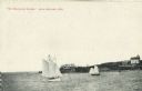
|---|---|
| Description: | View across water towards two schooners off the shore of Madeline Island, one of the islands that comprise the Apostle Islands in Lake Superior. Two large ... |
If you didn't find the material you searched for, our Library Reference Staff can help.
Call our reference desk at 608-264-6535 or email us at: