 Filter: Categories of Wisconsin Historical Images
Filter: Subject of Superior, Lake
Filter: Creator Name of Unknown
Filter: County of Douglas
Filter: Categories of Wisconsin Historical Images
Filter: Subject of Superior, Lake
Filter: Creator Name of Unknown
Filter: County of Douglas
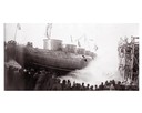
| Date: | 04 1893 |
|---|---|
| Description: | Launching Captain Abe McDougall's whaleback boat, "Christopher Columbus", from the American Steel Barge Company dock. |
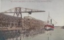
| Date: | |
|---|---|
| Description: | Colorized image of the frame of a large boat being built at the shipyards in Superior. |

| Date: | 1890 |
|---|---|
| Description: | Bird's-eye map of West Superior and Superior, with insets of Wright Farm and First Building in Superior. |

| Date: | 1913 |
|---|---|
| Description: | Aerial bridge and harbor, with a large boat passing underneath. A lamppost and a beacon are along the walkway towards the bridge on the left. Caption reads... |

| Date: | 1900 |
|---|---|
| Description: | Elevated view of Tower Avenue. Caption reads: "Tower Avenue, Superior, Wis." |

| Date: | 1920 |
|---|---|
| Description: | Elevated view of the harbor. Caption reads: "The Harbor, Superior, Wis." |

| Date: | 1885 |
|---|---|
| Description: | Illustrated view of Superior, as well as Omaha, Kansas City, St. Paul, and Winnipeg. Caption reads: "Superior - The Last Possible Great Marine City in the ... |

| Date: | 1930 |
|---|---|
| Description: | Caption reads: "'The Old Standby' First Lighthouse Built at the Head of Lake Superior—Superior Entry — 1854 Keepers, Com. Saxton and Samuel Palmer." |

| Date: | 1915 |
|---|---|
| Description: | Elevated view of the harbor. Caption reads: "The Harbor, Superior, Wis." |

| Date: | 1910 |
|---|---|
| Description: | Caption reads: "The Great Northern. One of the largest Elevators in the World, Superior, Wis." |
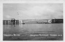
| Date: | 1940 |
|---|---|
| Description: | View of the Arrowhead Bridge at the Duluth-Superior Harbor. |

| Date: | 1911 |
|---|---|
| Description: | This map, taken from the 1911 Map of Wisconsin showing geology and roads by Hotchkiss and Thwaites, shows the northwest portion of Douglas County, Wisconsi... |

| Date: | 1930 |
|---|---|
| Description: | Shows county system of roads which are surfaced, well graded, common, or unimproved, town roads, state trunk highways, town and village boundaries, schools... |

| Date: | 1930 |
|---|---|
| Description: | Shows county system of roads which are surfaced, well graded, common, or unimproved, town roads, state trunk highways, town and village boundaries, schools... |

| Date: | 1890 |
|---|---|
| Description: | This map of Superior shows labeled streets, railroads, docks, city wards, and the state line. Relief is shown by hachures. Below the title reads: "Bedford ... |

| Date: | 1890 |
|---|---|
| Description: | This map of Superior shows city wards, bays, docks, some businesses and points of interest. Relief is shown by hachures. The back of the map features a typ... |

| Date: | 1898 |
|---|---|
| Description: | This map of Superior shows city wards, bays, docks, and some businesses and points of interest. Relief is shown by hachures. The map probably came from a C... |

| Date: | 1909 |
|---|---|
| Description: | This map of Duluth and Superior was issued by the Duluth Street Railway Company and shows street railway routes in the cities, as well as lakes, bays, harb... |

| Date: | 1951 |
|---|---|
| Description: | This map of Superior shows labeled streets, waterways, railroads, and company ownership of docks. |

| Date: | 1860 |
|---|---|
| Description: | This map of Superior is oriented with north to the upper left. Relief is shown by hachures and water depths are shown by soundings. Lake Superior and bays ... |
If you didn't find the material you searched for, our Library Reference Staff can help.
Call our reference desk at 608-264-6535 or email us at: