 Filter: Categories of Wisconsin Historical Images
Filter: Subject of Superior, Lake
Filter: Type of Map or Atlas
Filter: Subject of transportation
Filter: Categories of Wisconsin Historical Images
Filter: Subject of Superior, Lake
Filter: Type of Map or Atlas
Filter: Subject of transportation

| Date: | 01 1856 |
|---|---|
| Description: | This map shows lots, lots appropriated for churches and schools, streets, parks, court house, and land to be appropriated for railroad depots. An inset map... |

| Date: | 1900 |
|---|---|
| Description: | This map shows streets, railroads, dock and harbor lines, and parks. The map includes population tables for 1880, 1890, 1900. |

| Date: | 06 1923 |
|---|---|
| Description: | Sanborn map of Ashland, which includes Chequamegon Bay. |

| Date: | 1892 |
|---|---|
| Description: | This map shows the St. Louis Bay, Lake Superior, railroads, railroad yards, main roads, additions, and selected buildings in Superior and parts of the Town... |

| Date: | 1836 |
|---|---|
| Description: | This map was created to accompany a congressional report shows the then Wisconsin Territory, including present-day states of Wisconsin, Minnesota, Iowa, an... |
| Date: | 1853 |
|---|---|
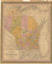
| Description: | This map shows counties in pink, orange, green, and yellow. Lake Michigan and Lake Superior are labeled as well as rivers and some geographical features. M... |

| Date: | 1912 |
|---|---|
| Description: | This map shows counties, roads, Lake Superior, Lake Michigan, and a portion of Illinois, Iowa, Minnesota, and Michigan. Also included is a list of railroad... |

| Date: | 1909 |
|---|---|
| Description: | This map covers Iron and Price Counties and portions of Sawyer and Oneida Counties. The map shows vacant and sold Wis. Central Ry. land, settlers houses, s... |

| Date: | 1939 |
|---|---|
| Description: | This illustrated map shows counties, highways, rivers, roads, present and proposed state parks and forests, proposed state parkways, proposed state monumen... |

| Date: | 1888 |
|---|---|
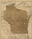
| Description: | This map shows counties, lakes, railroads, and rivers. Lake Michigan, Lake Superior, and the Apostle Islands are labeled. A table of railroad lines with mi... |

| Date: | 1908 |
|---|---|
| Description: | This map shows counties, roads, Lake Superior, Lake Michigan, and portions of surrounding states. Also included is a list of railroads showing miles and g... |

| Date: | 1910 |
|---|---|
| Description: | This map shows counties, roads, Lake Superior, Lake Michigan, and portions of surrounding states. Also included is a list of railroads showing miles and gr... |

| Date: | 1914 |
|---|---|
| Description: | This map shows counties, roads, Lake Superior, Lake Michigan, and portions of surrounding states. Also included is a list of railroads showing miles and gr... |

| Date: | 1923 |
|---|---|
| Description: | This map shows counties, roads, Lake Superior, Lake Michigan, and portions of surrounding states. Included is an index to cities, villages and other places... |

| Date: | 1921 |
|---|---|
| Description: | This map shows counties, roads, Lake Superior, Lake Michigan, and portions of surrounding states. Included is an index to cities, villages and other places... |
| Date: | 1881 |
|---|---|
| Description: | This map shows railroads by operator and projected railroads. Eastern Minnesota, the upper peninsula of Michigan, northeastern Iowa, and northern Illinois ... |

| Date: | 1910 |
|---|---|
| Description: | This map shows counties, roads, Lake Superior, Lake Michigan, and portions of surrounding states. Included is a table of interstate and intrastate railroa... |

| Date: | 1760 |
|---|---|
| Description: | This map shows lakes, rivers, forts, settlements, and Native American tribal territory. The southern boundary of the Hudsons Bay Company is labeled. Relief... |

| Date: | 1902 |
|---|---|
| Description: | This map includes six diagrams of the Great Lakes Region comparing advantages of geographical positions and strategic considerations. Portions of Iowa, Ill... |
If you didn't find the material you searched for, our Library Reference Staff can help.
Call our reference desk at 608-264-6535 or email us at:
