 Filter: Categories of Wisconsin Historical Images
Filter: Subject of Suburbs
Filter: Year of 1800-1899
Filter: Categories of Wisconsin Historical Images
Filter: Subject of Suburbs
Filter: Year of 1800-1899

| Date: | 1892 |
|---|---|
| Description: | Color bird's-eye map of Wauwatosa, looking east toward Milwaukee and Lake Michigan. Predominantly green with cream colored roadways, with six land plots ow... |
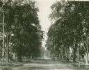
| Date: | 1896 |
|---|---|
| Description: | Jefferson Street south from Doty Street with trees lining the street. |

| Date: | 1891 |
|---|---|
| Description: | Map of a proposed subdivision. Map reads: "United States Investment Association SUBDIVISION No. 1 In S.W. 1/4 Sec. 33, Town 8, Range 22 East. Is situated a... |

| Date: | 1893 |
|---|---|
| Description: | This map covers west to Wauwatosa, north to North Milwaukee, and south to South Milwaukee and shows street railways, city limits, parks, roads, railroads, ... |
If you didn't find the material you searched for, our Library Reference Staff can help.
Call our reference desk at 608-264-6535 or email us at: