 Filter: Categories of Wisconsin Historical Images
Filter: Subject of Suburbs
Filter: Year of 1900-1999
Filter: Year of 1900-1909
Filter: Categories of Wisconsin Historical Images
Filter: Subject of Suburbs
Filter: Year of 1900-1999
Filter: Year of 1900-1909

| Date: | 1903 |
|---|---|
| Description: | Shows lot numbers and dimensions. "Issued May 31, 1903" -- Inscribed in ink. Oriented with north to the upper right. Includes text. Labelled streets are "R... |
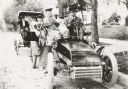
| Date: | 1903 |
|---|---|
| Description: | George S. Parker and family seated in their car, one of the first automobiles in Janesville. Behind them is a couple in another car. |

| Date: | 1906 |
|---|---|
| Description: | This map shows shows streets, subdivisions, railroads, places of interest including the State Capitol, the University of Wisconsin, Camp Randall, Henry Vil... |

| Date: | 1906 |
|---|---|
| Description: | This map shows ward boundaries, subdivisions, lot and block numbers and dimensions, house numbers, electric car lines, steam railways, and adjoining plat n... |

| Date: | 1906 |
|---|---|
| Description: | This map shows ward boundaries, lot and block numbers and dimensions, house numbers, electric car lines, steam railways, and adjoining plat numbers in a po... |

| Date: | 1901 |
|---|---|
| Description: | This map shows public schools, engine houses, railroads, street railways, city wards, parks, block numbers, and Lake Michigan. Also included are indexes, t... |

| Date: | 1906 |
|---|---|
| Description: | This map shows wards, schools, engine houses, railroads, street railways, block numbers, parks, roads, and Lake Michigan. Also included are indexes: Table ... |

| Date: | 1904 |
|---|---|
| Description: | This map has three inset maps of Whitefish Bay, Cudahy, and South Milwaukee. This map depicts schools, engine houses, railroads, street railways, city ward... |

| Date: | 1904 |
|---|---|
| Description: | This map shows wards, schools, engine houses, railroads, street railways, block numbers, parks, roads, and Lake Michigan. Also included are indexes: Table ... |

| Date: | 1908 |
|---|---|
| Description: | A Sanborn map of the isthmus, which includes the map key. |
If you didn't find the material you searched for, our Library Reference Staff can help.
Call our reference desk at 608-264-6535 or email us at: