 Filter: Categories of Wisconsin Historical Images
Filter: Subject of Suburbs
Filter: Subject of suburbs
Filter: Subject of transportation
Filter: Categories of Wisconsin Historical Images
Filter: Subject of Suburbs
Filter: Subject of suburbs
Filter: Subject of transportation

| Date: | 1891 |
|---|---|
| Description: | Map of a proposed subdivision. Map reads: "United States Investment Association SUBDIVISION No. 1 In S.W. 1/4 Sec. 33, Town 8, Range 22 East. Is situated a... |

| Date: | 1950 |
|---|---|
| Description: | This map is accompanied by booklet: "Know Milwaukee Map and Street Guide". The map is a detailed map of Milwaukee and the surrounding suburbs. Streets and ... |
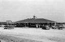
| Date: | 07 21 1958 |
|---|---|
| Description: | Exterior view of the Waterfall Motel and Restaurant, a one-story building with seven large picture windows. A free-standing sign that reads "Waterfall Rest... |

| Date: | 06 08 1960 |
|---|---|
| Description: | Blueprint plat of Sunset Hills sub-division. |

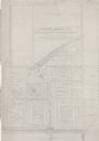
| Date: | 1903 |
|---|---|
| Description: | Shows lot numbers and dimensions. "Issued May 31, 1903" -- Inscribed in ink. Oriented with north to the upper right. Includes text. Labelled streets are "R... |

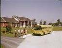
| Date: | 1973 |
|---|---|
| Description: | Color photograph of four children holding books and standing beside a gravel road in front of a suburban residence. An International rear-engine drive scho... |
| Date: | 1973 |
|---|---|
| Description: | Color photograph of a group of teenagers holding books and standing on the sidewalk in front of a suburban residence. In the background two girls are walki... |
| Date: | 03 03 1937 |
|---|---|
| Description: | A pencil drawing of a proposed area of the planned community of Greendale, Wisconsin. The community was established as an objective of the Department of Ag... |
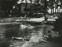
| Date: | 1957 |
|---|---|
| Description: | Suburban upper-class residence in wooded area with rock-lined swimming pool and swimming children. Two women sit in lawn chairs on the lawn near the house ... |
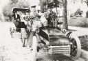
| Date: | 1903 |
|---|---|
| Description: | George S. Parker and family seated in their car, one of the first automobiles in Janesville. Behind them is a couple in another car. |
| Date: | 1938 |
|---|---|
| Description: | Architectural drawing of the Sunset Village neighborhood on the West side of the city of Madison. The poster description reads: A proposed master plan for ... |

| Date: | 10 19 1922 |
|---|---|
| Description: | Right side view of a circa 1922 International Harvester bus. The side of the bus reads: "West Suburban Transportation Co. Cicero, Berwyn, Riverside, Lyons,... |

| Date: | 04 04 1934 |
|---|---|
| Description: | Street map of the city of Milwaukee and surrounding communities at a scale of 1 inch to 1200 feet. |

| Date: | 1953 |
|---|---|
| Description: | Winter scene of a Milwaukee residential street corner with snow at night. |

| Date: | 1920 |
|---|---|
| Description: | This map shows the Nakoma neighborhood in Madison including the "Proposed Golf Ground." The map reads: "Nakoma--the Suburb Superb." The map includes texts ... |

| Date: | 1906 |
|---|---|
| Description: | This map shows shows streets, subdivisions, railroads, places of interest including the State Capitol, the University of Wisconsin, Camp Randall, Henry Vil... |

| Date: | 1966 |
|---|---|
| Description: | This map shows streets, highways, railroads, parks, colleges, cemeteries, county clubs, University of Wisconsin, Truax Field, Middleton, Shorewood Hills, M... |

| Date: | 1969 |
|---|---|
| Description: | This map is pen and ink on paper and shows the location of churches, local streets, railroads, parks, Middleton, Shorewood Hills, Monona, Maple Bluff, McFa... |

| Date: | 1968 |
|---|---|
| Description: | Three maps that show local streets, roads, railroads, parks, country clubs, the University of Wisconsin, Shorewood Hills, Maple Bluff, Monona, Truax Field,... |

| Date: | 1971 |
|---|---|
| Description: | This map shows streets, highways, railroads, parks, colleges, cemeteries, county clubs, University of Wisconsin, Truax Field, Middleton, Shorewood Hills, M... |
If you didn't find the material you searched for, our Library Reference Staff can help.
Call our reference desk at 608-264-6535 or email us at: