 Filter: Categories of Wisconsin Historical Images
Filter: Subject of Suburbs
Filter: Community of Madison
Filter: Subject of transportation
Filter: Categories of Wisconsin Historical Images
Filter: Subject of Suburbs
Filter: Community of Madison
Filter: Subject of transportation
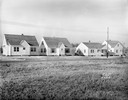
| Date: | 11 23 1938 |
|---|---|
| Description: | A row of houses at 826, 830, 834 & 838 North Fair Oaks Avenue built by the Fitzpatrick Lumber Company in what was the Town of Blooming Grove, now near East... |
| Date: | 02 26 1930 |
|---|---|
| Description: | Entrance to Westmorland subdivision on Mineral Point Road. |
| Date: | 08 26 1928 |
|---|---|
| Description: | Front view of the entrance to the North Gardens subdivision, on the corner of North Street and Hoard Street, owned by the Paul E. Stark Company. The stone ... |
| Date: | 07 26 1928 |
|---|---|
| Description: | Entrance to the North Gardens subdivision on the corner of North Street and Hoard Street, owned by Paul E. Stark Company. |

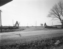
| Date: | 1955 |
|---|---|
| Description: | Blacktopping a new Madison residential street. Construction of the ranch-style houses in the background is almost complete. |

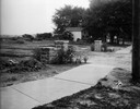
| Date: | 1955 |
|---|---|
| Description: | A construction crew blacktopping a Madison residential street. |
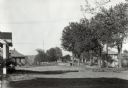
| Date: | |
|---|---|
| Description: | View of Nakoma Road looking northeast, with several houses and trees, and automobiles parked on the street. There is a woman standing on the steps of a por... |
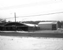
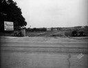
| Date: | 02 01 1957 |
|---|---|
| Description: | A metal store building and a metal warehouse building at 3320 University Avenue. In the background is a tree lined ridge. In the foreground is a two-lane r... |

| Date: | 06 08 1960 |
|---|---|
| Description: | Blueprint plat of Sunset Hills sub-division. |

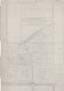
| Date: | 1903 |
|---|---|
| Description: | Shows lot numbers and dimensions. "Issued May 31, 1903" -- Inscribed in ink. Oriented with north to the upper right. Includes text. Labelled streets are "R... |
| Date: | 1938 |
|---|---|
| Description: | Architectural drawing of the Sunset Village neighborhood on the West side of the city of Madison. The poster description reads: A proposed master plan for ... |

| Date: | 1920 |
|---|---|
| Description: | This map shows the Nakoma neighborhood in Madison including the "Proposed Golf Ground." The map reads: "Nakoma--the Suburb Superb." The map includes texts ... |

| Date: | 1906 |
|---|---|
| Description: | This map shows shows streets, subdivisions, railroads, places of interest including the State Capitol, the University of Wisconsin, Camp Randall, Henry Vil... |

| Date: | 1966 |
|---|---|
| Description: | This map shows streets, highways, railroads, parks, colleges, cemeteries, county clubs, University of Wisconsin, Truax Field, Middleton, Shorewood Hills, M... |

| Date: | 1969 |
|---|---|
| Description: | This map is pen and ink on paper and shows the location of churches, local streets, railroads, parks, Middleton, Shorewood Hills, Monona, Maple Bluff, McFa... |

| Date: | 1968 |
|---|---|
| Description: | Three maps that show local streets, roads, railroads, parks, country clubs, the University of Wisconsin, Shorewood Hills, Maple Bluff, Monona, Truax Field,... |

| Date: | 1971 |
|---|---|
| Description: | This map shows streets, highways, railroads, parks, colleges, cemeteries, county clubs, University of Wisconsin, Truax Field, Middleton, Shorewood Hills, M... |

| Date: | 10 08 1945 |
|---|---|
| Description: | A barn on the Quaker Oats farm on 4202 Monona Drive. A sign above the barn door reads: "Branch Warehouse of William Le[?] Warehouses, Public Bonded Warehou... |

| Date: | 10 1911 |
|---|---|
| Description: | This map shows lot numbers, building lines, roads, trees, and Indian mounds. Relief is shown by contours. Includes manuscript annotations marking parks. |

| Date: | 1960 |
|---|---|
| Description: | Aerial view of rural landscape with suburban construction in foreground. Cottage Grove Road is at left with the newly constructed Acewood Boulevard crossin... |
If you didn't find the material you searched for, our Library Reference Staff can help.
Call our reference desk at 608-264-6535 or email us at: