 Filter: Categories of Wisconsin Historical Images
Filter: Subject of Suburbs
Filter: Community of Madison
Filter: Creator Name of Unknown
Filter: Categories of Wisconsin Historical Images
Filter: Subject of Suburbs
Filter: Community of Madison
Filter: Creator Name of Unknown
| Date: | |
|---|---|
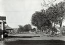
| Description: | View of Nakoma Road looking northeast, with several houses and trees, and automobiles parked on the street. There is a woman standing on the steps of a por... |

| Date: | 1920 |
|---|---|
| Description: | This map shows the Nakoma neighborhood in Madison including the "Proposed Golf Ground." The map reads: "Nakoma--the Suburb Superb." The map includes texts ... |

| Date: | 1969 |
|---|---|
| Description: | This map is pen and ink on paper and shows the location of churches, local streets, railroads, parks, Middleton, Shorewood Hills, Monona, Maple Bluff, McFa... |
If you didn't find the material you searched for, our Library Reference Staff can help.
Call our reference desk at 608-264-6535 or email us at: