 Filter: Categories of Wisconsin Historical Images
Filter: Subject of Suburbs
Filter: Creator Name of Unknown
Filter: Subject of neighborhoods
Filter: Categories of Wisconsin Historical Images
Filter: Subject of Suburbs
Filter: Creator Name of Unknown
Filter: Subject of neighborhoods
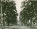
| Date: | 1896 |
|---|---|
| Description: | Jefferson Street south from Doty Street with trees lining the street. |
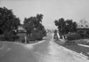
| Date: | |
|---|---|
| Description: | View of Nakoma Road looking northeast, with several houses and trees, and automobiles parked on the street. There is a woman standing on the steps of a por... |
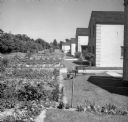
| Date: | 1939 |
|---|---|
| Description: | View down row of back of houses. The backyards have gardens, and on the far left is a row of trees. |
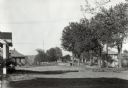
| Date: | 1920 |
|---|---|
| Description: | A view of a residential area, featuring houses, a fork in the road, sidewalks, and trees. |

| Date: | 1920 |
|---|---|
| Description: | This map shows the Nakoma neighborhood in Madison including the "Proposed Golf Ground." The map reads: "Nakoma--the Suburb Superb." The map includes texts ... |

| Date: | 1906 |
|---|---|
| Description: | This map shows ward boundaries, subdivisions, lot and block numbers and dimensions, house numbers, electric car lines, steam railways, and adjoining plat n... |
If you didn't find the material you searched for, our Library Reference Staff can help.
Call our reference desk at 608-264-6535 or email us at: