Filter: Categories of Wisconsin Historical Images
Filter: Subject of Streets
Filter: Year of 1800-1899
Filter: Categories of Wisconsin Historical Images
Filter: Subject of Streets
Filter: Year of 1800-1899

| Date: | 1875 |
|---|---|
| Description: | Bird's-eye map after a fire destroyed a large area of the town. In memory of the Great Conflagration on April 28th, 1875. Taken from the North-Side. |

| Date: | 1874 |
|---|---|
| Description: | Bird's-eye map of Racine, with an inset of Racine College. |

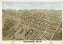
| Date: | 1893 |
|---|---|
| Description: | Bird's-eye map of Sturgeon Bay, looking Northeast. Area bordered by Church Street in top left corner, leather & Smith Bridge in bottom left corner, Lawrenc... |

| Date: | 1896 |
|---|---|
| Description: | Bird's-eye view of Washburn, with twenty vignettes around side, water in foreground with docks and lumber corral. Thirty-three locations identified in key ... |

| Date: | 1874 |
|---|---|
| Description: | Bird's-eye view of Waukesha, looking southwest, with insets of State Industrial School, Court House, and Fountain Spring House. |

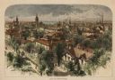
| Date: | 1879 |
|---|---|
| Description: | This map is a bird's-eye view of Wausau, the County Seat of Marathon County. The map features an index of points of interest. |

| Date: | 1870 |
|---|---|
| Description: | Bird's-eye view of Whitewater, with insets. |

| Date: | 1881 |
|---|---|
| Description: | Bird's-eye view of Appleton. |

| Date: | 1860 |
|---|---|
| Description: | Bird's-eye drawing of New Glarus. |
| Date: | 1874 |
|---|---|
| Description: | Bird's-eye view of Milwaukee looking southwest toward the county courthouse under construction in the public square west of St. John's Cathedral. |
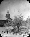
| Date: | 1860 |
|---|---|
| Description: | Elevated wintertime view of the intersection of South Carroll and West Main Streets, showing the First Baptist Church constructed in 1854, the wooden fence... |
| Date: | 1898 |
|---|---|
| Description: | The third Wisconsin State Capitol as seen from unpaved West Washington Avenue, with the West Wing to the left and the South Wing to the right. The church s... |
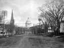
| Date: | 1873 |
|---|---|
| Description: | Elevated view of South Pinckney Street from the Wisconsin State Capitol, with East Washington Avenue to the left and Lake Monona on the distant right. The ... |

| Date: | 1854 |
|---|---|
| Description: | Bird's-eye view of Milwaukee looking east toward Lake Michigan from a bluff, long since graded into a slope, at about 6th Street between Wisconsin Avenue a... |
If you didn't find the material you searched for, our Library Reference Staff can help.
Call our reference desk at 608-264-6535 or email us at: