 Filter: Categories of Wisconsin Historical Images
Filter: Subject of Streets
Filter: Year of 1800-1899
Filter: Categories of Wisconsin Historical Images
Filter: Subject of Streets
Filter: Year of 1800-1899

| Date: | 1889 |
|---|---|
| Description: | Illustration of the exterior of the Fuller Opera House, which is a detail from a bird's-eye view map of Madison. |

| Date: | 1898 |
|---|---|
| Description: | Bird's-eye map of Milwaukee with prominent streets and buildings identified. Taken from City Hall Tower. |

| Date: | 1850 |
|---|---|
| Description: | Bird's-eye view of business district of Oshkosh, "drawn after nature" by the artist. |

| Date: | 1872 |
|---|---|
| Description: | Bird's-eye map of Milwaukee on Lake Michigan. |

| Date: | 1878 |
|---|---|
| Description: | Bird's-eye map of Chilton with insets of points of interest, including P.H. Becker's Brewery, Chilton House, and Gutheil's Block. |

| Date: | 1874 |
|---|---|
| Description: | Bird's-eye map of Chippewa Falls. |

| Date: | 1891 |
|---|---|
| Description: | Bird's-eye view of Eau Claire. |

| Date: | 1896 |
|---|---|
| Description: | Bird's-eye map of Fond du Lac, looking north west, with two insets of the P.H. Stamm residence, and the Proposed Lakeside Park. thirty-five locations ident... |

| Date: | 1893 |
|---|---|
| Description: | This photocopy of a bird’s-eye-view map shows illustrated houses and various buildings. Streets and the Rock River are labeled. An index to points of inter... |

| Date: | 1880 |
|---|---|
| Description: | Bird's-eye map over the Mississippi River of Fountain City. Paddle steamers and steamboats are on the river, and bluffs are in the background. |

| Date: | 1877 |
|---|---|
| Description: | Bird's-eye map of Janesville on the Rock River. |

| Date: | 1893 |
|---|---|
| Description: | Bird's-eye map of Jefferson, looking north. Crayfish River at left and center, Rock River from upper center to bottom center, joins at left of center; thir... |

| Date: | 12 21 1882 |
|---|---|
| Description: | Bird's-eye map of Kaukauna, from the Appleton Post Annual Review. |

| Date: | 1881 |
|---|---|
| Description: | Bird's-eye map of Milton Junction. |
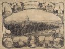
| Date: | 1864 |
|---|---|
| Description: | Bird's-eye view of Madison, with 12 vignettes and in the center is "The Capitol of Wisconsin View from the Capitol House". The buildings on the top are, fr... |

| Date: | 1861 |
|---|---|
| Description: | Bird's-eye map of Fond du Lac, "drawn after nature," with a parade of soldiers marching down the street. |
If you didn't find the material you searched for, our Library Reference Staff can help.
Call our reference desk at 608-264-6535 or email us at:


