Visit our other Wisconsin Historical Society websites!
 Filter: Categories of Wisconsin Historical Images
Filter: Subject of Streets
Filter: Subject of water
Filter: Categories of Wisconsin Historical Images
Filter: Subject of Streets
Filter: Subject of water

| Date: | 09 1871 |
|---|---|
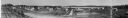
| Description: | Bird's-eye view of Peshtigo, before it was destroyed by fire on the night of October 8, 1871. |
| Date: | 1916 |
|---|---|
| Description: | Panoramic view of the Wingra area from the railroad tracks north of Gregory Street. Looking towards Lake Wingra, across Monroe Street. |

| Date: | 1907 |
|---|---|
| Description: | Buildings and storefronts in town near bridge and river. |

| Date: | 1870 |
|---|---|
| Description: | This bird's-eye-view map shows roads, a river with boats, and homes. The bottom margin of the map includes an index. |

| Date: | 1881 |
|---|---|
| Description: | Bird's-eye map of Marinette, with insets. |

| Date: | 1908 |
|---|---|
| Description: | Colored map showing a panoramic view of Madison in great detail. The Wisconsin State Capitol is located at the center, with Lake Mendota in the background ... |

| Date: | 1950 |
|---|---|
| Description: | Aerial view of the Wisconsin State Capitol building and surrounding Madison area. Lake Monona is in the background. |

| Date: | 1884 |
|---|---|
| Description: | A sign for Fauerbach's Brewery depicting a young woman and the brewery. |
| Date: | 1910 |
|---|---|
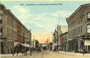
| Description: | Colorized view of King Street, looking east, with a streetcar. Lake Monona is in the background. Caption reads: "King Street, looking East, Madison, Wis." |

| Date: | 1908 |
|---|---|
| Description: | A panoramic aerial view of the Isthmus taken from a kite. Lake Mendota is to the right in the background with Picnic Point jutting into the lake. The photo... |
| Date: | 12 11 1926 |
|---|---|
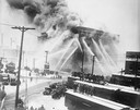
| Description: | Fire destroyed the Atlas Flour Mill, causing an estimated $100,000 in damage. Thirteen engine companies, six truck companies, and two fire boats fought the... |
| Date: | 04 24 1931 |
|---|---|
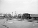
| Description: | Boathouses on Lake Monona looking southeast from E. Wilson Street across CNW railroad tracks. View of Wirka Boat Line, E. Wilson Street at S. Hancock Stree... |
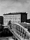
| Date: | |
|---|---|
| Description: | Exterior view of the Axtell House with Walker's Point Bridge in the foreground. |

| Date: | 1890 |
|---|---|
| Description: | Bird's-eye map of Ashland, viewed from Lake Superior, with insets of Prentice Park and Fishery. Population 16,000. Increase in Ten Years, 11,000. |
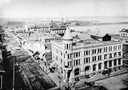
| Date: | 1891 |
|---|---|
| Description: | Elevated view looking west from the Knight Block. The Chequamegon Hotel and harbor are in the background. |
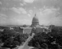
| Date: | 08 24 1945 |
|---|---|
| Description: | Elevated view of the Wisconsin State Capitol from the roof of the Loraine Hotel. |

| Date: | 07 10 1949 |
|---|---|
| Description: | Aerial view of Minocqua showing the surrounding lakes. |

| Date: | 1853 |
|---|---|
| Description: | Bird's-eye map of Milwaukee looking east toward Lake Michigan from a bluff, long since graded into a slope, at about 6th Street between Wisconsin Avenue an... |
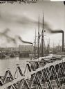
| Date: | |
|---|---|
| Description: | Elevated view of Milwaukee River from Walker's Point Bridge. |
If you didn't find the material you searched for, our Library Reference Staff can help.
Call our reference desk at 608-264-6535 or email us at:
