 Filter: Categories of Wisconsin Historical Images
Filter: Subject of Streets
Filter: Subject of voting
Filter: Categories of Wisconsin Historical Images
Filter: Subject of Streets
Filter: Subject of voting
| Date: | 1964 |
|---|---|
| Description: | Two men holding protest signs are walking down a sidewalk past a white police officer who is holding a bullhorn at a Greenwood Freedom Day. In the backgrou... |

| Date: | |
|---|---|
| Description: | A poster with an image of armed law enforcement officers surrounding a building during an election or voter education meeting. The text reads, "Voters Welc... |

| Date: | 1964 |
|---|---|
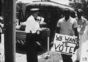
| Description: | View down sidewalk of two male protestors wearing signs around their necks walking down a sidewalk in a Freedom Summer civil rights demonstration. The sign... |

| Date: | 1964 |
|---|---|
| Description: | View towards sidewalk of a line of demonstrators carrying signs during a Freedom Summer civil rights demonstration. A man walking along the sidewalk holds ... |

| Date: | 1962 |
|---|---|
| Description: | This map shows the voting districts of Waukesha in red ink for the year 1962. The bottom of the map includes an index of streets. |

| Date: | 1948 |
|---|---|
| Description: | This map shows wards and precincts and includes a list of polling places by ward and precinct. The map reads: "Keep this Map . . . It Gives the Location of... |

| Date: | 1956 |
|---|---|
| Description: | This maps shows voting precincts and polling places as well as wards. Streets and the Sheboygan River are labeled. The bottom right of the map features a l... |

| Date: | 1948 |
|---|---|
| Description: | This map shows a list of polling places by ward and precinct in the left margin, a list of assembly districts, and additional handwritten notes. Lake Michi... |

| Date: | 1965 |
|---|---|
| Description: | This map shows wards, city limits, railroad right of way, proposed future streets, and approximate street elevations. Wards and public schools are labeled ... |

| Date: | 1965 |
|---|---|
| Description: | This map shows wards, schools and public buildings, and polling places. The map includes a street index. Lac La Belle, Fowler Lake, and Oconomowoc Lake are... |
If you didn't find the material you searched for, our Library Reference Staff can help.
Call our reference desk at 608-264-6535 or email us at: