 Filter: Categories of Wisconsin Historical Images
Filter: Subject of Streets
Filter: Subject of trails
Filter: Categories of Wisconsin Historical Images
Filter: Subject of Streets
Filter: Subject of trails

| Date: | 1906 |
|---|---|
| Description: | View from shoreline looking over a pathway towards the Steensland Bridge and Yahara River Parkway at East Washington Avenue. |
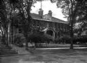
| Date: | |
|---|---|
| Description: | Front view of the Agricultural Building as seen from the street. The brick building is covered in ivy and features arch windows, a covered entrance, walkw... |
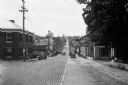
| Date: | 1930 |
|---|---|
| Description: | View down Midland Trail. Automobiles are parked on either side of the street outside an Amoco Station and other stores and dwellings. |

| Date: | |
|---|---|
| Description: | View of a tree-shaded lane with cottage homes, lined with fences on either sides. |

| Date: | 1942 |
|---|---|
| Description: | This map shows the route of the Milwaukee Road, roads, foot trails, resorts, and ranger stations. The map includes text, illustrations, a railroad fare tab... |
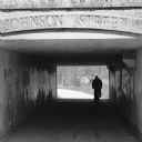
| Date: | 05 2014 |
|---|---|
| Description: | Silhouette of a person riding a bicycle through a pedestrian tunnel under East Johnson Street near the Yahara River and Tenney Park. Above the entrance to ... |
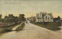
| Date: | 10 28 1907 |
|---|---|
| Description: | Text on front reads: "Maple Ave., Sawyer, Wis." A view of an unpaved street with a church and other buildings on the right. On the left is a path, fence an... |
If you didn't find the material you searched for, our Library Reference Staff can help.
Call our reference desk at 608-264-6535 or email us at: