 Filter: Categories of Wisconsin Historical Images
Filter: Subject of Streets
Filter: Subject of suburbs
Filter: Categories of Wisconsin Historical Images
Filter: Subject of Streets
Filter: Subject of suburbs

| Date: | 1940 |
|---|---|
| Description: | Advertising poster for the International delivery trucks. Features a color illustration of a De Luxe delivery trucks "with All-Steel . . . Streamlined Metr... |
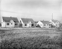
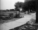
| Date: | 11 23 1938 |
|---|---|
| Description: | A row of houses at 826, 830, 834 & 838 North Fair Oaks Avenue built by the Fitzpatrick Lumber Company in what was the Town of Blooming Grove, now near East... |
| Date: | 1948 |
|---|---|
| Description: | Woman wearing a mink coat boarding an International Metro KB-3-M truck owned by Atlantic City Jitney Service. |
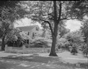
| Date: | 06 08 1935 |
|---|---|
| Description: | Tree-lined street in Lakewood subdivision. |
| Date: | 06 08 1935 |
|---|---|
| Description: | J. Frank Kessenich house, 205 Lakewood Boulevard, Lakewood subdivision. |
| Date: | 08 26 1928 |
|---|---|
| Description: | Front view of the entrance to the North Gardens subdivision, on the corner of North Street and Hoard Street, owned by the Paul E. Stark Company. The stone ... |
| Date: | 07 26 1928 |
|---|---|
| Description: | Entrance to the North Gardens subdivision on the corner of North Street and Hoard Street, owned by Paul E. Stark Company. |
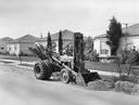
| Date: | 1954 |
|---|---|
| Description: | Man working on a suburban road with an International ID-6 and attached loader. The loader was manufactured by the Frank G. Hough Company. |

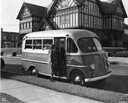
| Date: | 1951 |
|---|---|
| Description: | Color photograph of an International L-110 Truck (115-Inch W.B.) with panel body. The truck is parked on the side of a residential street, in front of a ho... |

| Date: | |
|---|---|
| Description: | A man is sitting at the wheel of a long steamroller parked in a gravel lot with a brick building in the background. |
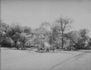
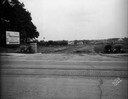
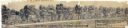
| Date: | 02 02 1978 |
|---|---|
| Description: | "The camera looks to the new subdivision and beyond." |

| Date: | 1950 |
|---|---|
| Description: | This map is accompanied by booklet: "Know Milwaukee Map and Street Guide". The map is a detailed map of Milwaukee and the surrounding suburbs. Streets and ... |

| Date: | 06 08 1960 |
|---|---|
| Description: | Blueprint plat of Sunset Hills sub-division. |

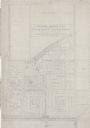
| Date: | 1903 |
|---|---|
| Description: | Shows lot numbers and dimensions. "Issued May 31, 1903" -- Inscribed in ink. Oriented with north to the upper right. Includes text. Labelled streets are "R... |
| Date: | 03 03 1937 |
|---|---|
| Description: | A pencil drawing of a proposed area of the planned community of Greendale, Wisconsin. The community was established as an objective of the Department of Ag... |
| Date: | 1938 |
|---|---|
| Description: | Architectural drawing of the Sunset Village neighborhood on the West side of the city of Madison. The poster description reads: A proposed master plan for ... |

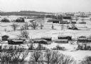
| Date: | 1953 |
|---|---|
| Description: | Winter scene of a Milwaukee residential street corner with snow at night. |

| Date: | 1920 |
|---|---|
| Description: | This map shows the Nakoma neighborhood in Madison including the "Proposed Golf Ground." The map reads: "Nakoma--the Suburb Superb." The map includes texts ... |

| Date: | 1966 |
|---|---|
| Description: | This map shows streets, highways, railroads, parks, colleges, cemeteries, county clubs, University of Wisconsin, Truax Field, Middleton, Shorewood Hills, M... |

| Date: | 1969 |
|---|---|
| Description: | This map is pen and ink on paper and shows the location of churches, local streets, railroads, parks, Middleton, Shorewood Hills, Monona, Maple Bluff, McFa... |
If you didn't find the material you searched for, our Library Reference Staff can help.
Call our reference desk at 608-264-6535 or email us at: