 Filter: Categories of Wisconsin Historical Images
Filter: Subject of Streets
Filter: Subject of shipping
Filter: Categories of Wisconsin Historical Images
Filter: Subject of Streets
Filter: Subject of shipping

| Date: | 1890 |
|---|---|
| Description: | Bird's-eye map of Ashland, viewed from Lake Superior, with insets of Prentice Park and Fishery. Population 16,000. Increase in Ten Years, 11,000. |
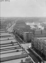
| Date: | |
|---|---|
| Description: | Milwaukee, south from Mitchell Block. View shows rooftops and building fronts. Ships and bridge are in the background on the right. |
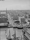
| Date: | |
|---|---|
| Description: | Elevated view west from Mitchell Block of warehouses, industrial buildings and a church in the background. In the foreground is a waterway with a schooner ... |

| Date: | 1873 |
|---|---|
| Description: | Bird's-eye map of La Crosse from the Mississippi River. |

| Date: | 10 19 1936 |
|---|---|
| Description: | Allied Van Lines truck in front of Whalen Transfer Co., 605 University Avenue. |
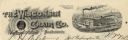
| Date: | |
|---|---|
| Description: | Memohead of the Wisconsin Chair Company of Port Washington, Wisconsin, with its McLean patented swing rocking chair set against a circular background with ... |

| Date: | 1990 |
|---|---|
| Description: | Map of bike routes in Madison. Lower right corner features a system map with legend. Upper left corner is an inset of the Capital Loop with labelled points... |

| Date: | 1890 |
|---|---|
| Description: | This map of Superior shows city wards, bays, docks, some businesses and points of interest. Relief is shown by hachures. The back of the map features a typ... |

| Date: | 1951 |
|---|---|
| Description: | This map of Superior shows labeled streets, waterways, railroads, and company ownership of docks. |

| Date: | 1887 |
|---|---|
| Description: | This map shows lot and block numbers, established dock lines, docks, slips, railroads, and streets of West Superior in 1887. |

| Date: | 1889 |
|---|---|
| Description: | This map shows lot and block numbers, established dock lines, docks, slips, railroads, and streets of West Superior in 1889. |
If you didn't find the material you searched for, our Library Reference Staff can help.
Call our reference desk at 608-264-6535 or email us at: