Visit our other Wisconsin Historical Society websites!
 Filter: Categories of Wisconsin Historical Images
Filter: Subject of Streets
Filter: Subject of rivers
Filter: Categories of Wisconsin Historical Images
Filter: Subject of Streets
Filter: Subject of rivers

| Date: | 09 1871 |
|---|---|
| Description: | Bird's-eye view of Peshtigo, before it was destroyed by fire on the night of October 8, 1871. |

| Date: | 1907 |
|---|---|
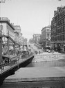
| Description: | Buildings and storefronts in town near bridge and river. |

| Date: | 1870 |
|---|---|
| Description: | This bird's-eye-view map shows roads, a river with boats, and homes. The bottom margin of the map includes an index. |

| Date: | 1881 |
|---|---|
| Description: | Bird's-eye map of Marinette, with insets. |
| Date: | |
|---|---|
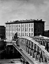
| Description: | Exterior view of the Axtell House with Walker's Point Bridge in the foreground. |

| Date: | 1853 |
|---|---|
| Description: | Bird's-eye map of Milwaukee looking east toward Lake Michigan from a bluff, long since graded into a slope, at about 6th Street between Wisconsin Avenue an... |
| Date: | |
|---|---|
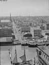
| Description: | Elevated view of Milwaukee River from Walker's Point Bridge. |
| Date: | |
|---|---|
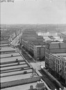
| Description: | Milwaukee, south from Mitchell Block. View shows rooftops and building fronts. Ships and bridge are in the background on the right. |
| Date: | |
|---|---|
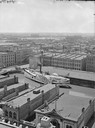
| Description: | Elevated view of Milwaukee, looking southwest from Mitchell block showing buildings, and the paddle steamer John A. Dix. |
| Date: | |
|---|---|
| Description: | Elevated view of Grand Avenue and a bridge over the river, with streetcar and horse-drawn vehicles on the street. |
| Date: | |
|---|---|
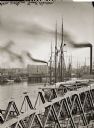
| Description: | Elevated view west from Mitchell Block of warehouses, industrial buildings and a church in the background. In the foreground is a waterway with a schooner ... |
| Date: | |
|---|---|
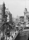
| Description: | View up Wisconsin Avenue towards a bridge with pedestrian and horse-drawn vehicle traffic. Buildings along a street are in the distance. |

| Date: | 1890 |
|---|---|
| Description: | Bird's-eye map of Beloit with insets of Williams Engine Works, Eclipse Wind Engine Co., and John Foster & Co. Turtle Creek is in the lower section, and the... |

| Date: | 1868 |
|---|---|
| Description: | This 1868 birds-eye view depicts the buildings, streets, railroad, vegetation and topography of Columbus, Wisconsin. The high school, cemetery, railroad de... |

| Date: | 1867 |
|---|---|
| Description: | Bird's-eye map of Green Bay and Fort Howard, Brown Co., depicts street names and street layouts, houses, trees, and the East River. A reference key at the ... |

| Date: | 1836 |
|---|---|
| Description: | The top map is the "Plat of Madison the Capitol of Wisconsin." The bottom map is the "Map of the Four Lake Country. Taken from the Township Maps in the U.S... |

| Date: | 1898 |
|---|---|
| Description: | Bird's-eye map of Milwaukee with prominent streets and buildings identified. Taken from City Hall Tower. |

| Date: | 1850 |
|---|---|
| Description: | Bird's-eye view of business district of Oshkosh, "drawn after nature" by the artist. |

| Date: | 1872 |
|---|---|
| Description: | Bird's-eye map of Milwaukee on Lake Michigan. |
If you didn't find the material you searched for, our Library Reference Staff can help.
Call our reference desk at 608-264-6535 or email us at:
