 Filter: Categories of Wisconsin Historical Images
Filter: Subject of Streets
Filter: Subject of persons
Filter: Type of Map or Atlas
Filter: Creator Name of Unknown
Filter: Categories of Wisconsin Historical Images
Filter: Subject of Streets
Filter: Subject of persons
Filter: Type of Map or Atlas
Filter: Creator Name of Unknown

| Date: | 1860 |
|---|---|
| Description: | Bird's-eye drawing of New Glarus. |

| Date: | 1970 |
|---|---|
| Description: | A map of parks of Kewaunee County, Wisconsin, showing the fishing spots, lakes and parks in the area, it also provides a location map of the area. On the ... |
| Date: | 1954 |
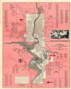
|---|---|
| Description: | This map of Wausau is pink, red, gray, and white. The map includes indexes of streets, industries, and community buildings and features a photograph of the... |
If you didn't find the material you searched for, our Library Reference Staff can help.
Call our reference desk at 608-264-6535 or email us at: